Charity Shoal Crater, an Exhumed Middle Ordovician Impact Crater
Holcombe, T. L., S. Youngblut, and N. Slowey, 2013,
Geological structure of Charity Shoal crater, Lake
Ontario, revealed by multi beam bathymetry. Geo-Marine
Letters. col. 33, no. 4, pp 245-252
http://link.springer.com/article/10.1007%2Fs00367-013-0322-6
http://adsabs.harvard.edu/abs/2013GML....33..245H
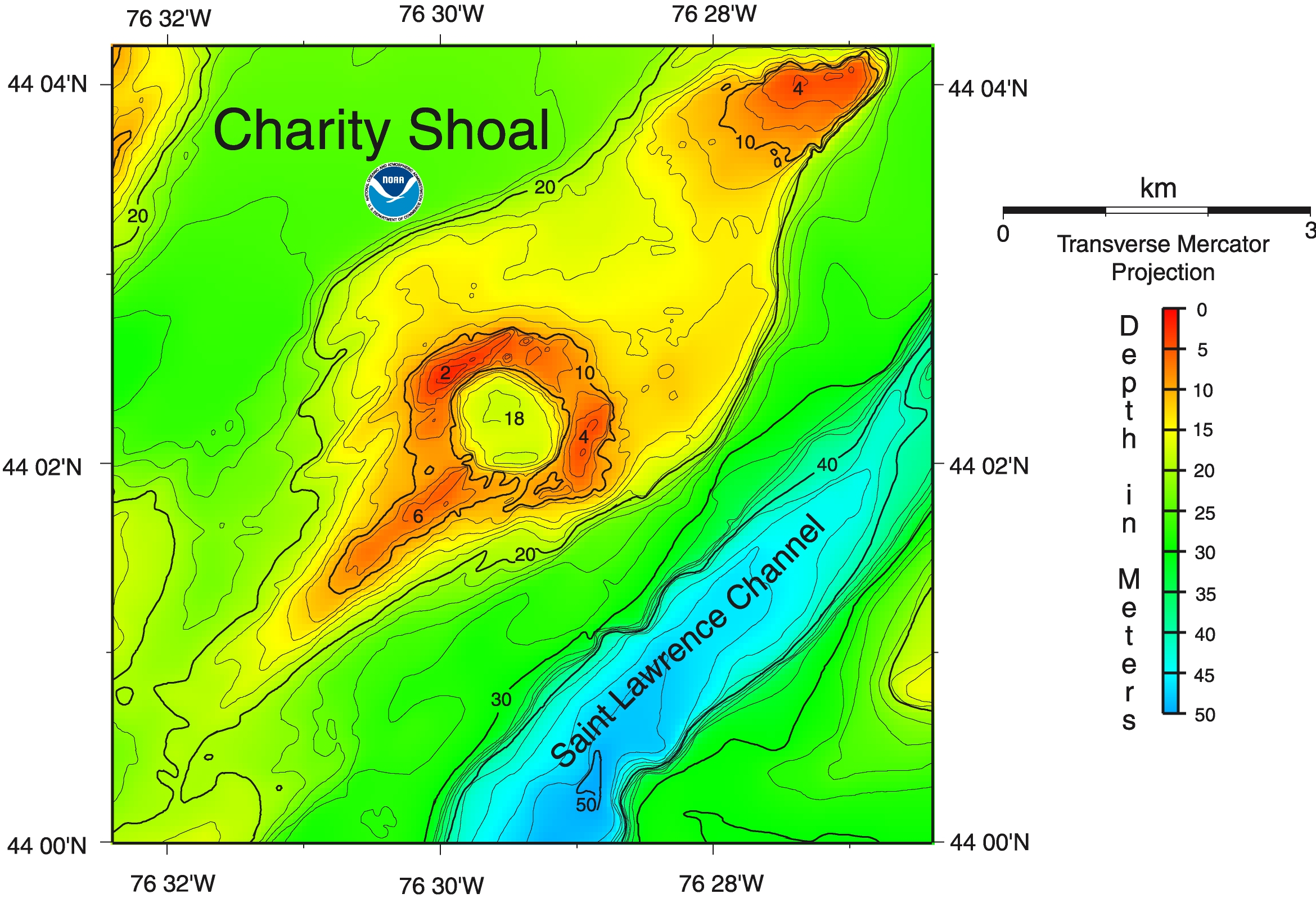
They argue that the Charity Shoal Crater in Lake
Ontario formed as the result of an extraterrestrial
impact event in a shallow marine environment during
the Middle Ordovician. After the impact, it was
eventually buried by post-impact marine
sedimentation, which covered it with fossiliferous
marine carbonate strata. Much later, they argue,
it was exhumed by Pleistocene glacial erosion.
Other publications are:
Holcombe, T. L., J. S. Warren, D. F. Reid, W. T.
Virden, and D. L. Divins, 2001, Small Rimmed Depression
in Lake Ontario: An Impact Crater? Journal of Great
Lakes Research. vol. 27, no. 4, pp. 510-517
PDF file at http://www.glerl.noaa.gov/pubs/fulltext/2001/20010012.pdf
abstract at https://www.sciencedirect.com/science/journal/03801330/27/4
Phillip, S. A., 2013, High-resolution lake-based
magnetic mapping and modelling of basement structures,
with examples from Küçükçekmece Lagoon, Turkey and
Charity Shoal, Lake Ontario. unpublished MS thesis,
School of Geography and Earth Sciences, McMaster
University, Hamilton, Ontario. 113 pp.
https://macsphere.mcmaster.ca/handle/11375/13532
Bathymetric map of Charity Crater area.
Great Lakes Data Rescue Project - Lake Ontario Bathymetry
https://www.ngdc.noaa.gov/mgg/greatlakes/lakeontario_cdrom/html/area12.htm
https://www.ngdc.noaa.gov/mgg/greatlakes/lakeontario_cdrom/images/a12_lg.jpg
Yours,
Paul H.
