New methodology for Estimating Size of Impact Craters
New methodology provides better size estimates of meteorite
impact craters. University of Western Ontario, August 8, 2016
http://mediarelations.uwo.ca/2016/08/05/new-methodology-provides-better-size-estimates-meteorite-impact-craters/
http://phys.org/news/2016-08-methodology-size-meteorite-impact-craters.html
The paper is:
Osinski, G. R., and L. Ferrière, 2016, Shatter cones: (Mis)understood?
Science Advances. Science Advances. Vol. 2, no. 8, e1600616
DOI: 10.1126/sciadv.1600616
http://advances.sciencemag.org/content/2/8/e1600616
Yours,
Paul H.

Showing posts with label impact craters. Show all posts
Showing posts with label impact craters. Show all posts
Wednesday, 24 August 2016
Tuesday, 4 September 2012
Pseudocraters Never Die (Phillips County, Montana)
Pseudocraters Never Die (Phillips County, Montana)
On the Internet, known pseudocraters ( craterwrongs )
never seem to die. They seem to get endlessly recycled
as seen in a rambling article, “The Younger Dryas Impact
Event and the Cycles of Cosmic Catastrophes,” reprinted
by RH on July 5, 2012 at:
http://nexusilluminati.blogspot.com/2012/07/younger-dryas-impact-event-and-cycles.html
This web page cites:
Geologists may have found 'new' meteor crater – Montana
by Annette Hayden, Havre Daily News, June 11, 2007.
http://sinkholeswww.sott.net/articles/show/134335-Geologists-may-have-found-new-meteor-crater-Montana
This circular feature is located at Latitude: 47.804896°:
Longitude: -108.631878° in Phillips County, Montana,
about 14.5 km southwest of Zortman, Montana.
as can be seen at:
http://maps.google.com/maps?f=q&hl=en&q=montana&ie=UTF8&ll=47.827793,-108.679848&spn=0.071453,0.150719&t=h&z=13&iwloc=addr&om=1
and http://www.sott.net/image/image/1705/NewMeteorCraterMinn.gif
Unfortunately, these circular features are not impact craters.
These features, which partially surround the Little Rocky
Mountains, are eroded surfaces of circular structural domes
created by the uplift of sedimentary strata overlying laccolithic
intrusions composed of syenite porphry.
These laccoliths are discussed in "Geology and Physiography
of Fort Belknap" at:
http://serc.carleton.edu/research_education/nativelands/ftbelknap/geology.html
A geologic cross section of these circular features can
be found at:
http://serc.carleton.edu/images/research_education/nativelands/ftbelknap/crosssection.gif
According to the above web page, a laccolith is a “concordant
igneous intrusion that has domed the overlying rocks and has
a known or assumed flat floor and a postulated dikelike
feeder beneath its thickest point. It is roughly circular in plan,
less than five miles in diameter, and from a few feet to several
hundred feet in thickness.”
The geology of these features is illustrated by:
Porter, K. W., and E. M. Wilde, 2001, Geologic map of the
Zortman 30' x 60' quadrangle, eastern Montana, Montana
Bureau of Mines and Geology. Open-File Report 438,
16 p., 1 sheet(s), 1:100,000.
http://www.mbmg.mtech.edu/mbmgcat/public/ListCitation.asp?selectby=series&series_type=MBMG&series_number=438&series_sub=&
This report is available from:
http://www.mbmg.mtech.edu/pdf_100k/zortman-text.pdf
The 4.2 MB PDF file of the geologic map is available from:
http://www.mbmg.mtech.edu/pdf_100k/zortman.pdf
Publications about these circular geologic structures are:
Collier, A. J., and S. H. Cathcart, 1922, Possibility of finding
oil in laccolithic domes south of the Little Rocky Mountains,
Montana. Bulletin 736-F (pp. F171-F178) United States
Geological Survey, reston, Virginia.
http://pubs.usgs.gov/bul/0736f/report.pdf
http://ngmdb.usgs.gov/Prodesc/proddesc_93198.htm
Knechtel, M. M., 1944, Oil and gas possibilities of the plains
adjacent to the Little Rocky Mountains, Montana. Oil and Gas
Investigations Map no. OM-4, scale 1:48000, U.S. Geological
Survey, Reston, Virginia.
http://ngmdb.usgs.gov/Prodesc/proddesc_32205.htm
Knechtel, M.M., 1959, Stratigraphy of the Little Rocky
Mountains and encircling foothills, Montana. Bulletin
no. 1072-N, U.S. Geological Survey, Reston, Virginia.
http://pubs.usgs.gov/bul/1072n/report.pdf
http://ngmdb.usgs.gov/Prodesc/proddesc_20726.htm
Web pages:
Laccolith - http://en.wikipedia.org/wiki/Laccolith
2. What's a laccolith? - http://formontana.net/2a.html
Syenite - http://en.wikipedia.org/wiki/Syenite
I survived Hurricane Isaac without any damage. My
power was off from about noon August 29th to about
10:30 PM, August 30th. So we were extremely lucky.
However, there are thousand of people, who were
badly hurt by Hurricane Isaac and can use any help
and prayers that can be given them.
American Red Cross – Louisiana
http://www.arcno.org
http://www.batonrouge.redcross.org
Best wishes,
Paul H.
On the Internet, known pseudocraters ( craterwrongs )
never seem to die. They seem to get endlessly recycled
as seen in a rambling article, “The Younger Dryas Impact
Event and the Cycles of Cosmic Catastrophes,” reprinted
by RH on July 5, 2012 at:
http://nexusilluminati.blogspot.com/2012/07/younger-dryas-impact-event-and-cycles.html
This web page cites:
Geologists may have found 'new' meteor crater – Montana
by Annette Hayden, Havre Daily News, June 11, 2007.
http://sinkholeswww.sott.net/articles/show/134335-Geologists-may-have-found-new-meteor-crater-Montana
This circular feature is located at Latitude: 47.804896°:
Longitude: -108.631878° in Phillips County, Montana,
about 14.5 km southwest of Zortman, Montana.
as can be seen at:
http://maps.google.com/maps?f=q&hl=en&q=montana&ie=UTF8&ll=47.827793,-108.679848&spn=0.071453,0.150719&t=h&z=13&iwloc=addr&om=1
and http://www.sott.net/image/image/1705/NewMeteorCraterMinn.gif
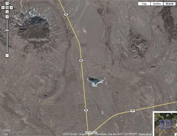
Unfortunately, these circular features are not impact craters.
These features, which partially surround the Little Rocky
Mountains, are eroded surfaces of circular structural domes
created by the uplift of sedimentary strata overlying laccolithic
intrusions composed of syenite porphry.
These laccoliths are discussed in "Geology and Physiography
of Fort Belknap" at:
http://serc.carleton.edu/research_education/nativelands/ftbelknap/geology.html
A geologic cross section of these circular features can
be found at:
http://serc.carleton.edu/images/research_education/nativelands/ftbelknap/crosssection.gif
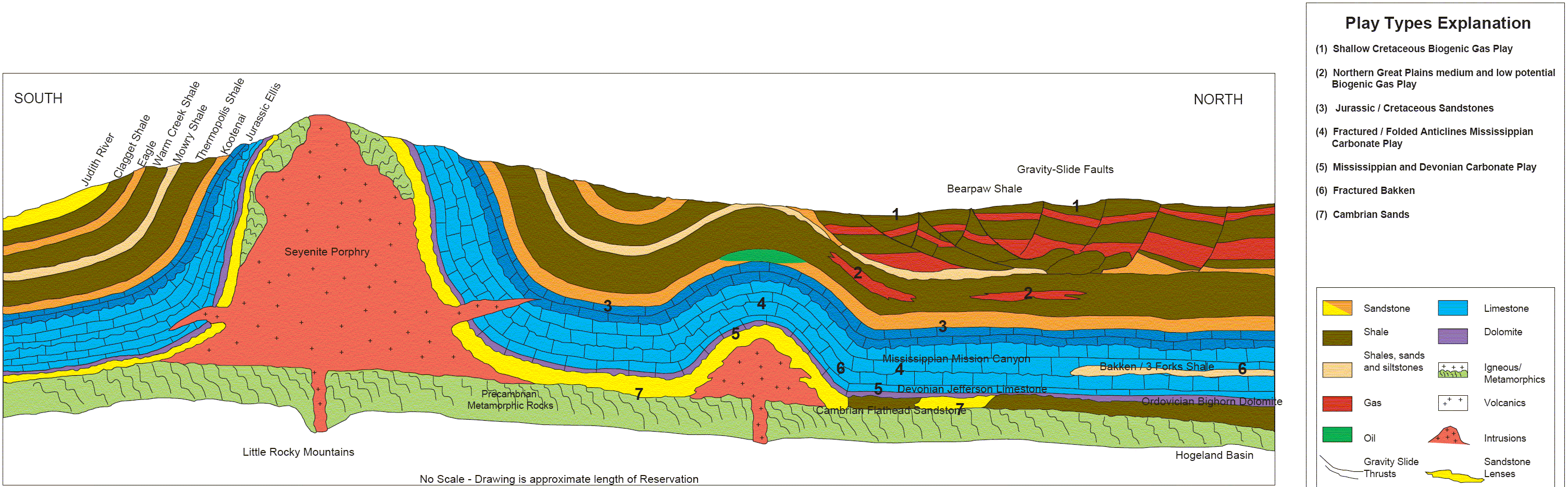
According to the above web page, a laccolith is a “concordant
igneous intrusion that has domed the overlying rocks and has
a known or assumed flat floor and a postulated dikelike
feeder beneath its thickest point. It is roughly circular in plan,
less than five miles in diameter, and from a few feet to several
hundred feet in thickness.”
The geology of these features is illustrated by:
Porter, K. W., and E. M. Wilde, 2001, Geologic map of the
Zortman 30' x 60' quadrangle, eastern Montana, Montana
Bureau of Mines and Geology. Open-File Report 438,
16 p., 1 sheet(s), 1:100,000.
http://www.mbmg.mtech.edu/mbmgcat/public/ListCitation.asp?selectby=series&series_type=MBMG&series_number=438&series_sub=&
This report is available from:
http://www.mbmg.mtech.edu/pdf_100k/zortman-text.pdf
The 4.2 MB PDF file of the geologic map is available from:
http://www.mbmg.mtech.edu/pdf_100k/zortman.pdf
Publications about these circular geologic structures are:
Collier, A. J., and S. H. Cathcart, 1922, Possibility of finding
oil in laccolithic domes south of the Little Rocky Mountains,
Montana. Bulletin 736-F (pp. F171-F178) United States
Geological Survey, reston, Virginia.
http://pubs.usgs.gov/bul/0736f/report.pdf
http://ngmdb.usgs.gov/Prodesc/proddesc_93198.htm
Knechtel, M. M., 1944, Oil and gas possibilities of the plains
adjacent to the Little Rocky Mountains, Montana. Oil and Gas
Investigations Map no. OM-4, scale 1:48000, U.S. Geological
Survey, Reston, Virginia.
http://ngmdb.usgs.gov/Prodesc/proddesc_32205.htm
Knechtel, M.M., 1959, Stratigraphy of the Little Rocky
Mountains and encircling foothills, Montana. Bulletin
no. 1072-N, U.S. Geological Survey, Reston, Virginia.
http://pubs.usgs.gov/bul/1072n/report.pdf
http://ngmdb.usgs.gov/Prodesc/proddesc_20726.htm
Web pages:
Laccolith - http://en.wikipedia.org/wiki/Laccolith
2. What's a laccolith? - http://formontana.net/2a.html
Syenite - http://en.wikipedia.org/wiki/Syenite
I survived Hurricane Isaac without any damage. My
power was off from about noon August 29th to about
10:30 PM, August 30th. So we were extremely lucky.
However, there are thousand of people, who were
badly hurt by Hurricane Isaac and can use any help
and prayers that can be given them.
American Red Cross – Louisiana
http://www.arcno.org
http://www.batonrouge.redcross.org
Best wishes,
Paul H.

Sunday, 3 July 2011
Recent estimate of yet-to-find impact craters on Earth
Recent estimate of yet-to-find impact craters on Earth
A recent attempt to estimate the number of impact craters
remaining to be found is:
Stewart, S. A., 2011, Estimates of yet-to-find impact crater
population on Earth. Journal of the Geological Society.
vol. 168, no. 1, pp. 1-14.
http://jgs.lyellcollection.org/content/168/1/1.abstract
He estimates that there are about 845 impact craters larger
than 1 km in diameter that have been preserved over the
Phanerozoic. Of these, he estimates that about 714 craters,
of which 228 craters are larger than 2.5 km, are yet to be found.
Yours,
Paul H.
Saturday, 16 April 2011
Geomorphology, including impact craters, of Martian volcanoes
Geomorphology, including impact craters, of Martian volcanoes
Mist-capped volcanoes of Mars: The amazingly clear
images that show how the Red Planet was transformed
by meteor impacts, Daily Mail, April 7, 2011
http://www.dailymail.co.uk/sciencetech/article-1373984/Mist-capped-volcanoes-Mars-The-amazing-images-Red-Planet-transformed-meteor-impacts.html
Neighboring volcanoes on Mars, Physorg, April 4, 2011
http://www.physorg.com/news/2011-04-neighboring-volcanoes-mars.html
Mars Express: Ceraunius und Uranius Tholi
http://www.astroarts.org/solscape/2011/04/06/mars-express-ceraunius-und-uranius-tholi/
Spectacular image at above web page at:
http://www.astroarts.org/solscape/files/2011/04/ceraunius_uranius_tholi_color.jpg
Digital Elevation Model of Ceraunius Tholus and Uranius
Tholus, European Space Agency,
http://www.esa.int/esa-mmg/mmg.pl?b=b&type=I&idf=SEMJ7L6UPLG&single=y&start=1
Yours,
Paul H.
Saturday, 31 January 2009
Non-impact origin of the crater field in the Gilf Kebir region (SW Egypt)
Non-impact origin of the crater field in the Gilf Kebir region (SW Egypt)
Paul bristolia at yahoo.comSat Jan 31 12:34:52 EST 2009
Dear Friends
For what is (or is not) worth I found these references while looking
for something else.
Non-impact origin of the crater field in the Gilf Kebir region
(SW Egypt) by M. Di Martino, L. Orti, L. Matassoni2, M.
Morelli, R. Serra, abnd A. Buzzigoli PDF file at:
http://sci.esa.int/science-e/www/object/doc.cfm?fobjectid=40214
Another file can found at:
http://www.rssd.esa.int/SYS/include/pubs_display.php?project=MARSEXPRESS&id=1324871
and finally there is:
http://www.rssd.esa.int/SYS/include/pubs_display.php?project=MARSEXPRESS&id=1006109
Some other web pages:
1. Remarks to the origin of the craters around Gilf Kebir and
Djebel Uweinat (Egypt) and the supposed impact craters of
Libya. 3. A not credible message to a so named crater "Kebira"
by Norbert Brügge, Germany’
http://www.b14643.de/Sahara/Clayton%20Craters/index.htm
2. Pseudo Shatter Cones in the Western Desert (Egypt)
by Norbert Brügge, Germany
http://www.b14643.de/Sahara/Shatter%20Cones/index.htm
Yours,
Paul H.
Baton Rouge, LA
Thursday, 22 January 2009
Free PDF Files of GSA Fieldguides Now Available - Includes Impact Craters
Free PDF Files of GSA Fieldguides Now Available - Includes Impact Craters
Paul bristolia at yahoo.comThu Jan 22 23:02:45 EST 2009
Dear Friends,
The chapters of the following GSA field guides can
downloaded freely as PDf files for an unknown period
of time.
Some chapters, which deal with impact craters are:
1. The Jeptha Knob cryptoexplosion structure, Kentucky
by C. Ronald Seeger, Centennial Field Guide Volume 6
http://www.gsajournals.org/archive/0-8137-5406-2/6/0/pdf/i0-8137-5406-2-6-0-17.pdf
2. The Calvin 28 cryptoexplosive disturbance, Cass
County, Michigan by Randall L. Milstein, Centennial
Field Guide Volume 3
http://www.gsajournals.org/archive/0-8137-5403-8/3/0/pdf/i0-8137-5403-8-3-0-315.pdf
3. The Kentland Dome, Indiana: A structural anomaly
by Raymond C. Gutschick, Centennial Field Guide Volume 3
http://www.gsajournals.org/archive/0-8137-5403-8/3/0/pdf/i0-8137-5403-8-3-0-337.pdf
and 4. Meteor Crater, Arizona by Eugene M. Shoemaker,
Centennial Field Guide Volume 2
http://www.gsajournals.org/archive/0-8137-5402-X/2/0/pdf/i0-8137-5402-X-2-0-399.pdf
Many other PDF files for these field guides can be found at:
Centennial Field Guide Volume 1, Cordilleran Section of
the Geological Society of America ISBN: 0-8137-5401-1
http://www.gsajournals.org/perlserv/?request=get-specialpub-toc&isbn=0-8137-5401-1
Centennial Field Guide Volume 2 Rocky Mountain Section of the
Geological Society of America ISBN: 0-8137-5402-X
http://www.gsajournals.org/perlserv/?request=get-specialpub-toc&isbn=0-8137-5402-X
Centennial Field Guide Volume 3 North-Central Section of the
Geological Society of America ISBN: 0-8137-5403-8
http://www.gsajournals.org/perlserv/?request=get-specialpub-toc&isbn=0-8137-5403-8
Centennial Field Guide Volume 4 South-Central Section of the
Geological Society of America ISBN: 0-8137-5404-6
http://www.gsajournals.org/perlserv/?request=get-specialpub-toc&isbn=0-8137-5404-6
Centennial Field Guide Volume 5 Northeastern Section of the
Geological Society of America ISBN: 0-8137-5405-4
http://www.gsajournals.org/perlserv/?request=get-specialpub-toc&isbn=0-8137-5405-4
Centennial Field Guide Volume 6 Southeastern Section of the
Geological Society of America ISBN: 0-8137-5406-2
http://www.gsajournals.org/perlserv/?request=get-specialpub-toc&isbn=0-8137-5406-2
The links to all of these volumes can be found as links in
"Field Guides" at http://www.gsajournals.org/perlserv/?request=get-collection&coll_title=Field%20Guides
Yours,
Paul H.
Thursday, 20 September 2007
Downloadable (PDF) World Map of Impact Craters, Volcanoes, and Tectonics
Downloadable (PDF) World Map of Impact Craters, Volcanoes, and Tectonics
Paul bristolia at yahoo.comWed Sep 19 08:48:17 EDT 2007
The United States Geological Survey's world map of
volcanoes, earthquakes, impact craters, and plate
tectonics is available online as PDF files. It is:
This Dynamic Planet World Map of Volcanoes, Earthquakes,
Impact Craters, and Plate Tectonics, Third Edition, 2006,
By Tom Simkin, Robert I. Tilling, Peter R. Vogt, Stephen
H. Kirby, Paul Kimberly, and David B. Stewart, United
States Geological Survey Geologic Investigations Map
no. I-2800
http://pubs.usgs.gov/imap/2800/
"This map shows the Earth's physiographic features, the
current movements of its major tectonic plates, and the
locations of its volcanoes, earthquakes, and impact craters.
Over 1,500 volcanoes active during the past 10,000 years
are plotted on the map in four age categories. The locations
( epicenters) of over 24,000 earthquakes, largely from 1960
through 1990, are plotted in three magnitude categories and
in two depth ranges. This PDF file includes 6 pages of
explanatory and background information, a legend for the
map in landscape mode, schematic cross section, and the
map itself, which is 44 inches wide."
They have both screen and print versions of the PDF files.
Yours,
Paul H.
Sunday, 11 March 2007
Impact Origin of Carolina Bays Argued For at 2007 AGU Meeting
Impact Origin of Carolina Bays Argued For at 2007 AGU Meeting
Paul bristolia at yahoo.comSat Mar 10 15:00:15 EST 2007
Dear Friends,
Apparently, there is going to be some interesting papers
at the 2007 Joint Assembly of the American Geophysical
Union as there will be a session presenting evidence for
an impact having occurred during Younger-Dyras times
at the "end of the last Ice Age. Below are links to
representative abstracts:
1. Evidence for an Extraterrestrial Impact Event 12,900 years
ago that Contributed to Megafaunal Extinctions and the Younger
Dryas Cooling
http://submissions5.agu.org/aguconvener/ConvenerView.asp?ref=1388
2. Formation of the Carolina Bays: ET Impact vs. Wind-and-Water
http://submissions5.agu.org/aguconvener/ConvenerView.asp?ref=1334
3. Extraterrestrial Markers Found at Clovis Sites Across North
America
http://submissions5.agu.org/aguconvener/ConvenerView.asp?ref=1393
4. Is There Evidence for Impact-Triggered Fires at the End
Pleistocene?
http://submissions5.agu.org/aguconvener/ConvenerView.asp?ref=513
The session itself is " PP05: New Insights into Younger Dryas
Climatic Instability, Mass Extinction, the Clovis People, and
Extraterrestrial Impacts
http://www.agu.org/meetings/ja07/?content=search&show=detail&sessid=159
It looks like Firestone and his supporters are refining their
arguments and dropping the implausible ones, i.e. the so-called
meteor crater in Lake Michigan, and concentrating on what they
regard the basic evidence for their ideas.
Best Regards,
Paul H.
Monday, 9 October 2006
Re: Egypt's Craters Pose Geological Riddle
Re: Egypt's Craters Pose Geological Riddle
Paul bristolia at yahoo.comMon Oct 9 14:10:02 EDT 2006
In “Egypt's Craters Pose Geological Riddle”, Ron
Baalke wrote:
> http://dsc.discovery.com/news/2006/10/06/crater_pla.html?category=travel&guid=20061006103030
> Egypt's Craters Pose Geological Riddle, Larry O'Hanlon
> Discovery News October 6, 2006
There are a number of links, which provided more detail
about this ongoing controversy. They are:
1. Remarks to the origin of the craters around Gilf
Kebir and Djebel Uweinat (Egypt)and the supposed
impact craters of Libya by Norbert Brugge, Germany,
2004, at
http://hometown.aol.de/SLVehicles4/Clayton%20Craters/Clayton-Craters.htm
2. di Martino, and others, 2006, Non-Impact Origin of
the Crater Field in the Gilf Kebir Region (SW Egypt).
European Space Agency First International Conference on
Impact Cratering in the Solar System ESTEC, Noordwijk,
The Netherlands, 08 - 12 May, 2006. The abstract can
be found at:
http://www.rssd.esa.int/SYS/docs/ll_transfers/296053_dimartino.pdf
and 3. The actual presentation of the above paper can
be found at
Non-impact origin of the crater field in the Gilf
Kebir region (SW Egypt) by M. Di Martino, L. Orti,
L. Matassoni, M. Morelli, R. Serra, and A. Buzzigoli.
The 3.3 MB PDF can be found file at:
http://www.rssd.esa.int/SYS/docs/ll_transfers/296053_Di2DMartino_pres.pdf
and in “40th ESLAB First International Conference on Impact
Cratering in the Solar System Agenda, Monday 8 May 2006 at:
http://sci.esa.int/science-e/www/object/index.cfm?fobjectid=39029
On page 25 of the above PDF file, Di Martino and coauthors
dispute the impact origin of what has been called the “Kebira
crater” in Libya - Egypt.
Yours,
Paul H.
Thursday, 16 March 2006
How to Discover Asteroid Impacts
How to Discover Asteroid Impacts
Paul bristolia at yahoo.comWed Mar 15 17:06:20 EST 2006
How to discover asteroid impacts
The story of the discovery of two impact craters
By Emilio González, March 13, 2006
http://www.astroseti.org/impacts.php
Monday, 29 November 2004
An Opportunity For Public Service, Profit, and Publicity
An Opportunity For Public Service, Profit, and Publicity
Paul H bristolia at yahoo.comSun Nov 28 20:10:52 EST 2004
While looking around on the Internet, I
found an opportunitye for the meteorite
community to do a public service and, at
the same time possibly profit for their
contributions.
This ooportunity exists at the "Earth
Science World ImageBank" at:
http://www.earthscienceworld.org/imagebank/
"The Earth Science World ImageBank is a
service provided by the American Geological
Institute (AGI). This ImageBank is designed
to provide quality geoscience images to the
public, educators, and the geoscience
community."
First, the meteorite community could do a
public service by submitting representative
pictures of meteorites, tektites, impactites,
impact craters, meteorite thin sections,
and anything else related to meteorites. As
far as I found this database has only one
picture of a meteorite and no images of
tektites. It would certainly would be a
public service to contribute pictures of
meteorites and related items, which can be
used for educational purposes. I am using
the word "contribute" because the person
submitting the pictures still retains
copyright on it and can still require a
fee for any commercial use.
It would be a public service if a collection
of meteorite photographs could be submitted
to this web site that included an example
of each different type of meteorite and a
selection of pictures of historically
important falls. Also, pictures of craters,
meteorites as they are found in the field,
impactites, shocked belenmites, shocked
quartz, etc. would be an important
contribution.
Second, one feature of the image data bank
is that a person can permit the free use
of their images for specific educational
purposes and, yet, require people, who want
to use an image for commercial purposes,
pay them a set fee for each use of one of
their images. Thus, not only can a person
perform a public service by providing
images of meteorites, impact craters,
impactites, tektites, thin sections, and
so forth, they also can profit from an
image in the database, if someone wants
to use it for commercial purposes.
Finally, the people on this list should
note that the name of the person or company
hdoling teh copyright is displayed in the
database. This gives them some free publicity.
Also, if an image is used for educational
purposes, the database requests that the
proper credit be given to it. Again, the
contributors will get some more free
publicity whenever their image is used.
For details of how to contribute, go to:
http://www.earthscienceworld.org/imagebank/submit/index.html
"The Earth Science World ImageBank is
always looking to collect more high-
quality geoscience images for this
growing collection. The primary mission
of the ESWIB is to provide these images
to educators, the geoscience community,
and the public for non-commercial use.
Your contribution and assistance in
helping us develop this lasting resource
will not only benefit the scientific
community, but also help to enhance
Earth System education."
Best Regards,
Paul
Baton Rouge, LA
Subscribe to:
Posts (Atom)