Washington Obsidian Source - Obsidian Outcrops
In “Washington Obsidian Source” at
http://lists.drizzle.com/pipermail/rockhounds/2012-June/037936.html
Sonja Kassa wrote,
“Still, I am an amateur, and would like advice/knowledge
about obsidian outcrops and how they occur or if anyone
has run into a similar situation and has advice! I would love
to hear it!”
Go look at:
1. the “U. S. and Canada Obsidian Source Catalog” at
http://www.sourcecatalog.com/
2. the “World Obsidian Source Catalog” at
http://www.obsidianlab.com/sourcecatalog/s_home.html
and 3. “Northwest Research Obsidian Studies Laboratory
Map Library “at
http://www.obsidianlab.com/image_maps/image_maps.html
Best wishes,
Paul H.

Tuesday, 12 June 2012
Monday, 11 June 2012
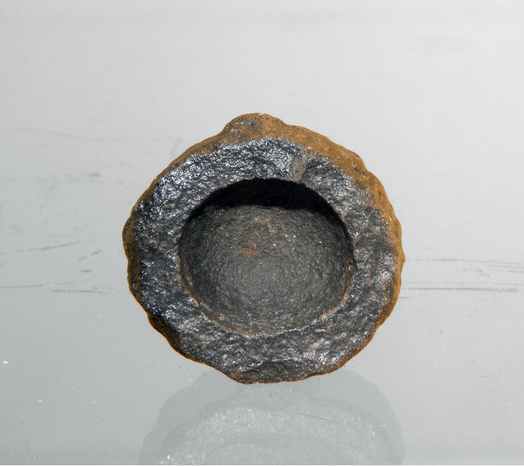
Hollow meteorite on ebay
Hollow meteorite on ebay
In “hollow meteorite on ebay“ at:
http://six.pairlist.net/pipermail/meteorite-list/2012-June/085666.html
Werner Schroer wrote:
“I just found this interesting looking specimen on ebay.
http://tinyurl.com/6teew4b
Are there any other hollow meteorites out there? ;)”
This is does not look at all like a meteorite. It looks
like a classic example of an ordinary hollow hematite
/ goethite concretion, which is common known
by rockhounds as either “Indian paint pots” or
“rattle stones.”
For examples, see pictures in “Goethite” at:
http://www.mindat.org/forum.php?read,73,216497,216497
1. Goethite, USA, Ohio, Licking Co., Washington
Township Weathered concretion.
http://www.mindat.org/arphotos/400-0581774001280588865.jpg
http://www.mindat.org/forum.php?read,73,216497,216497
2. Goethite 2.5cm wide
http://www.mindat.org/arphotos/380-0165545001282277241.jpg
http://www.mindat.org/forum.php?read,73,216497,216497
Concretions of Garvies Point
http://www.garviespointmuseum.com/concretions.php
I have seen outcrops in Louisiana, i.e. the sand pit at
Eddie Jones State Park, Caddo Parish, where numerous
concretions identical to this eBay specimen had eroded
out and were eroding of the ground by erosion.
Some random papers about such concretions are:
Loope, D. B., R. M. Kettler, K. A. Weber, N. L. Hinrichs, and
D. T. Burgess, 2012 , Rinded iron-oxide concretions:
Hallmarks of altered siderite masses of both early and
late diagenetic origin: Sedimentology. Article first
published online: 12 MAR 2012
http://www.geosciences.unl.edu/~dloope/pdf/RindedIronSedimentology.pdf
http://www.geosciences.unl.edu/~dloope/
http://onlinelibrary.wiley.com/doi/10.1111/j.1365-3091.2012.01325.x/abstract
Smith, L. L., 1948, Hollow Ferruginous Concretions in
South Carolina. The Journal of Geology. vol. 56, no. 3,
pp. 218-225.
http://www.jstor.org/discover/10.2307/30063390?uid=3739688
Van Der Burg, W.J., 1970, The formation of rattle stones
and the climatological factors which limited their
distribution in the Dutch Pleistocene, 2. The climatological
factors Palaeogeography, Palaeoclimatology, Palaeoecology.
vol. 7, no. 4, pp. 297–308. (July 1970)
http://www.sciencedirect.com/science/article/pii/0031018270900982
van Loef, J. J., 2000, Composition and genesis of
rattlestones from Dutch soils as shown by Mössbauer
spectroscopy, INAA and XRD. Geologie en Mijnbouw
(Netherlands Journal of Geosciences) vol. 79, no. 1, pp. 59-71
http://www.njgonline.nl/publish/articles/000021/article.pdf
Best wishes,
Paul H.
Funny rock stories, poems, jokes? - Friends of Pleistocene Songbook
Funny rock stories, poems, jokes? - Friends of Pleistocene Songbook
Kitty wrote,
"Bill & I have had a lot of depressing and stressful days for the last
couple of weeks so we'd like to have some happy, funny, silly,
uplifting, stories, poems, jokes, etc. to cheer us up and distract us.
Besides, the present thread is interesting and thought-provoking, but
I'd like a break.
Anybody able to cheer up a couple of sad rockhounds?"
There is the 2009 "Friends of the Pleistocene Songbook" at:
http://www.uaf.edu/files/aqc/FOPsongbook2009.pdf
Friends of Pleistocene - Alaska Cell
http://www.uaf.edu/aqc/friends-of-the-pleistocen/
The scientific stuff can found in "2008 Juneau
FOP guidebook" at
http://www.uaf.edu/files/aqc/DraftFOPSEAK2008.pdf
and the 2010 guidebook at
http://www.uaf.edu/aqc/friends-of-the-pleistocen/2010/
Best wishes,
Paul H.
--
Thursday, 7 June 2012
Mysterious radiation burst recorded in tree rings (774–775 AD)
Mysterious radiation burst recorded in tree rings (774–775 AD)
Cosmic rays showered Earth 1230 years ago, but
where from? Los Angeles Times, June 4, 2012
http://www.latimes.com/news/science/sciencenow/la-sci-sn-cosmic-ray-increase-20120604,0,6401794.story?track=rss
Mysterious radiation burst recorded in tree rings
(Spike in carbon-14 levels indicates a massive
cosmic event — but supernovae and solar flares
ruled out.) by Richard A. Lovett, June 2, 2012
http://www.nature.com/news/mysterious-radiation-burst-recorded-in-tree-rings-1.10768
The paper is:
Miyake, F., K. Nagaya, K. Masuda, and T.
Nakamura, 2012, A signature of cosmic-ray
increase in ad 774–775 from tree rings in
Japan. Nature. Published online June 3, 2012.
http://www.nature.com/nature/journal/vaop/ncurrent/full/nature11123.html
Best wishes,
Paul H.
Missed the Venus Transit in 2012? Watch It Online Until 2117
Missed the Venus Transit in 2012? Watch It Online Until 2117
Missed the Venus Transit in 2012? Watch It Online Until 2117
PC World, June 6, 2012
http://www.pcworld.com/article/257056/missed_the_venus_transit_in_2012_watch_it_online_until_2117.html
For Scientists of the 18th Century, the Transit of Venus Was
Their Final Chance to Measure the Solar System. The Atlantic
http://www.theatlantic.com/technology/archive/2012/06/for-scientists-of-the-18th-century-the-transit-of-venus-was-their-final-chance-to-measure-the-solar-system/258013/
NASA 2012 Venus Transit WEbpage
http://venustransit.gsfc.nasa.gov/
and data at http://venustransit.gsfc.nasa.gov/data
Best wishes,
Paul H.
Missed the Venus Transit in 2012? Watch It Online Until 2117
PC World, June 6, 2012
http://www.pcworld.com/article/257056/missed_the_venus_transit_in_2012_watch_it_online_until_2117.html
For Scientists of the 18th Century, the Transit of Venus Was
Their Final Chance to Measure the Solar System. The Atlantic
http://www.theatlantic.com/technology/archive/2012/06/for-scientists-of-the-18th-century-the-transit-of-venus-was-their-final-chance-to-measure-the-solar-system/258013/
NASA 2012 Venus Transit WEbpage
http://venustransit.gsfc.nasa.gov/
and data at http://venustransit.gsfc.nasa.gov/data
Best wishes,
Paul H.
Tuesday, 5 June 2012
NASA Live Venus Transit Webcasts
NASA Live Venus Transit Webcasts
NASA Live Venus Transit Webcasts
http://sunearthday.nasa.gov/2012/transit/webcast.php
and http://sunearthday.nasa.gov/webcasts/nasaedge/
Rare Transit Of Venus 'A Beautiful Event
http://www.npr.org/2012/06/05/154319951/rare-transit-of-venus-a-beautiful-event
Transit of Venus
http://www.transitofvenus.org/
Yours,
Paul H.
Sunday, 3 June 2012
Maps Showing Stages in the Deglaciation of North America
Maps Showing Stages in the Deglaciation of North America
For those people interested in background information for
the Younger Dryas impact hypothesis, a paper with maps
showing the stages in the last Pleistocene deglaciation of
North America can downloaded from online for free for a
period of time.
The paper is:
Dyke, A. S., 2004, An outline of North American deglaciation
with emphasis on central and northern Canada. in J. Ehlers and
P.L. Gibbard, eds., pp. 373-424, Quaternary Glaciations-Extent
and Chronology — Part II: North America. vol. 2, Part B.
Elsiever, New York, New York.
The paper can be downloaded from
http://academic.macewan.ca/furzem/files/2011/10/Dyke-2004.pdf
The link to this paper is in "October 3rd – Yellowknife" at
http://academic.macewan.ca/furzem/2011/10/03/october-3rd-yellowknife/
An animation showing the deglaciation of North America
can be found in “The Last Deglaciation of North America,
21,400 - 5700 years ago, animation” at
http://emvc.geol.ucsb.edu/2_infopgs/IP2IceAge/aDeglacNoAm.html
Best wishes,
Paul H.
A Western Crater Field? - Flathead_Lake
A Western Crater Field? - Flathead_Lake
In “A Western Crater Field?” at
http://six.pairlist.net/pipermail/meteorite-list/2012-May/085463.html
E.P. Grondine wrote:
“Hi all -
A while back, I related to you the Assiniboine memories
of the Holocene Start Impact Event (HSIE):
… URLs to unrelated previous posts omitted…
“I think that there is data to suspect that the lake
the Assinboine remembered waz Flathead Lake:
http://en.wikipedia.org/wiki/Flathead_Lake
If you look at the current west-north-west exit of
the lake in this image:
http://en.wikipedia.org/wiki/File:Flathead_lake.jpg
you will see what appear to be several astroblemes.
The exit of this lake prior to their formation appears
to have been south down a river which would have
formed a rather perfect animal migration path.
Whether they are or not will require proper geological
field examination.”
The structural and Quaternary geology of Flathead Lake
has been studied in great detailed and the results of these
studies have been published in a series of peer-reviewed
journal papers and other scientific publications. This
research included detailed field study, including geologic
mapping, of the Flathead Lake area; high-resolution
gravity surveys of the Flathead Lake area; 270 km of
single channel, 3.5 kHz reflection seismic reflection data
of sediment underlying Flathead Lake; a set of eight,
5 to 11.5 m long, piston cores taken from the bottom of
Flathead Lake; and additional low-frequency seismic
data gathered by the United States Geological Survey.
All of this data and research clearly demonstrates a
lack of any evidence for extraterrestrial impact having
been associated with the formation of Flathead Lake and
soundly refutes any such hypothesis. This research
demonstrates that Flathead Lake occupies the actively
subsiding southern end of a rift valley known as the Rocky
Mountain Trench. The seismic data shows five different
periods of increased tectonic activity and associated
subsidence have occurred during the last 15,000 years.
The core and seismic data show that acoustically-stratified,
undisturbed Pleistocene glacial lake and Holocene sediment
underlies the bottom of Lake Flathead. The cores and
seismic data demonstrates that the oldest of these sediments
date to about 14,475±150 cal yr BP, the maximum age of
the oldest varves. This is when the main Flathead Lake
basin was at least partially deglaciated and lake sediments
could start accumulating within the basin now occupied
by Flathead Lake. Field studies of the area around Flathead
Lake show that the southern shore of this lake is formed
by a recessional moraine of glacial origin, which acts as
dam. The north shore of Flathead Lake consists of younger
recessional glacial moraines. Although volcanic ash beds
are preserved in lake and glacial sediments, there is a
complete absence of any disturbance or event beds,
which can be interpreted as being related to any sort of
extraterrestrial impact since the deglaciation of the area
between 13,000 to 15,000 years.
References about Flathead Lake include:
Edwards, J., 2006, Evidence for Glacial Outburst Floods
along the Lower Flathead River: Results from Geologic
Mapping, Geomorphologic Analysis, and a Gravity Survey
near Polson, Montana. unpublished MSc thesis, University
of Montana, Missoula, Montana.
http://etd.lib.umt.edu/theses/available/etd-02282007-160250/
Hoffmann, M. H., 2005, Sedimentary record of glacial
dynamics, lake level fluctuations, and tectonics:
Late Pleistocene-Holocene structural and stratigraphic
analysis of the Flathead Lake basin and the Mission
Valley, Montana, USA. Unpublished PhD. dissertation,
University of Montana, Missoula, Montana.
http://gradworks.umi.com/32/05/3205772.html
Hofmann, M. H., and M. S. Hendrix, 2010, Depositional
processes and the inferred history of ice-margin
retreat associated with the deglaciation of the
Cordilleran Ice Sheet: The sedimentary record
from Flathead Lake, northwest Montana, USA
Sedimentary Geology. vol. 223, no. 1-2, pp. 61–74
http://www.sciencedirect.com/science/article/pii/S0037073809002322
Hofmann, M. H., M. S. Hendrix, J. N. Moore, and M. Sperazza,
2006a, Late Pleistocene and Holocene depositional history
of sediments in Flathead Lake, Montana: evidence
from high-resolution seismic reflection interpretation.
Sedimentary Geology. vol. 184, no. 1, pp. 111–131.
http://www.sciencedirect.com/science/article/pii/S0037073805003325
Hofmann, M. H., M. S. Hendrix, J. N. Moore, and M. Sperazza,
2006b, Neotectonic evolution and fault geometry change
along a major extensional fault system in the Mission and
Flathead Valleys, NW-Montana. Journal of Strucutral Geology.
vol. 28, no. 7, pp. 1244–1260.
http://www.sciencedirect.com/science/article/pii/S0191814106000885
LaFave, J. I., L. N. Smith, and T. W. Patton, 2004,
Ground-water resources of the Flathead Lake Area:
Flathead, Lake, and parts of Missoula and Sanders counties.
Montana Ground-Water assessment Atlas no. 2, The
Montana Bureau of Mines and Geology, Butte, Montana.
http://www.mbmg.mtech.edu/mbmgcat/public/ListCitation.asp?pub_id=10310&
Smith, L. N., 2001. Hydrogeologic framework of the southern
part of the Flathead Lake Area, Flathead, Lake, Missoula, and
Sanders Counties, Montana. Montana Bureau of Mines and
Geology, Montana Ground-Water Assessment Atlas No.2,
Part B, Map 10.
Smith, L. N., 2004. Late Pleistocene stratigraphy and implications
for deglaciation and subglacial processes of the Flathead
Lobe of the Cordilleran Ice Sheet, Flathead Valley, Montana,
USA. Sedimentary Geology, vol. 165, No. 3-4, pp. 295–332.
http://www.sciencedirect.com/science/article/pii/S0037073803003427
http://gsa.confex.com/gsa/2004RM/finalprogram/abstract_72168.htm
Wold, R. J., 1982. Seismic reflection study of Flathead Lake,
Montana. Miscellaneous field studies map no. MF-1433,
scale 1:117,647. U.S. Geological Survey, Reston, Virginia
Best wishes,
Paul H.
Monday, 21 May 2012
Person "Nearly Hit by Meteorite" Again :-) :-) (this Time Bulgaria)
Person "Nearly Hit by Meteorite" Again :-) :-) (this Time Bulgaria)
Bulgarian Man nearly Hit by Meteorite
Environment | April 28, 2012, Saturday| 1011 views
http://novinite.com/view_news.php?id=138881
I was not able to find out anything more this story.
Best wishes,
Paul H.
Bulgarian Man nearly Hit by Meteorite
Environment | April 28, 2012, Saturday| 1011 views
http://novinite.com/view_news.php?id=138881
I was not able to find out anything more this story.
Best wishes,
Paul H.
Monday, 14 May 2012
A Visit to the Only American Mine for Rare Earth Metals
A Visit to the Only American Mine for Rare Earth Metals
A Visit to the Only American Mine for Rare Earth Metals
by Fixers Feb 21 2012,
http://www.theatlantic.com/technology/archive/2012/02/a-visit-to-the-only-american-mine-for-rare-earth-metals/253372/
Best wishes,
Paul H.
A Visit to the Only American Mine for Rare Earth Metals
by Fixers Feb 21 2012,
http://www.theatlantic.com/technology/archive/2012/02/a-visit-to-the-only-american-mine-for-rare-earth-metals/253372/
Best wishes,
Paul H.
OT - Solar Eclipse 2012: When And Where To See It Best
OT - Solar Eclipse 2012: When And Where To See It Best
Solar Eclipse 2012: When And Where To See
It Best, Huffington Post, May 10, 2012
http://www.huffingtonpost.com/2012/05/10/solar-eclipse-2012-when-where-time-date_n_1505683.html
Annular Solar Eclipse Track: May 20, 2012
Space.com, May 11, 2012
http://www.space.com/15662-annular-solar-eclipse-photo-guide-2012.html
How to Watch the Solar Eclipse From Mount Fuji’s Peak
Sonia Paul, Mashable, April 20, 2012
http://mashable.com/2012/04/20/japan-solar-eclipse/
Panasonic to Webcast Solar Eclipse From Top
of Mt. Fuji, Wall street Journal, May 9, 2012,
http://blogs.wsj.com/japanrealtime/2012/05/09/panasonic-to-webcast-solar-eclipse-from-top-of-mt-fuji/?mod=google_news_blog
Best wishes,
Paul H.
Saturday, 12 May 2012
World's Smallest Drawf Mammoth is Identified
World's Smallest Drawf Mammoth is Identified
World's smallest mini mammoth is identified
Natural History Museum,
World's smallest mini mammoth is identified
Natural History Museum,
http://www.nhm.ac.uk/about-us/news/2012/may/worlds-smallest-mini-mammoth-is-identified110024.html
Dwarf Mammoth Found On Crete Was Smallest Ever,
Mammuthus Creticus Fossils Suggest (VIDEO)
Huffington Post, May 2, 2012,
Dwarf Mammoth Found On Crete Was Smallest Ever,
Mammuthus Creticus Fossils Suggest (VIDEO)
Huffington Post, May 2, 2012,
http://www.huffingtonpost.com/2012/05/09/dwarf-mammoth-crete-smallest_n_1502561.html
Mini mammoth once roamed Crete (Evolution crafted
pint-sized pachyderm on Mediterranean island
by Sid Perkins, May 9, 2012, Nature News,
http://www.nature.com/news/mini-mammoth-once-roamed-crete-1.10605
The paper is:
Herridge, V. L., and A. M. Lister, 2012, Extreme
insular dwarfism evolved in a mammoth. Proceedings
of the Royal Academy of Science. Published online
before print May 9, 2012, doi: 10.1098/rspb.2012.0671
http://rspb.royalsocietypublishing.org/content/early/2012/05/04/rspb.2012.0671
Best wishes,
Paul H.
--
Friday, 11 May 2012
Transfer of Meteoroids Between Planetary Systems
Transfer of Meteoroids Between Planetary Systems
Chaotic exchange of solid material between planetary systems:
implications for lithopanspermia by E. Belbruno, A. Moro-Martin,
R. Malhotra, and D. Savransky. Accepted by Astrobiology on
May 2, 2012. http://arxiv.org/abs/1205.1059
PDF file at http://arxiv.org/pdf/1205.1059v1.pdf
Best wishes,
Paul H.
Chaotic exchange of solid material between planetary systems:
implications for lithopanspermia by E. Belbruno, A. Moro-Martin,
R. Malhotra, and D. Savransky. Accepted by Astrobiology on
May 2, 2012. http://arxiv.org/abs/1205.1059
PDF file at http://arxiv.org/pdf/1205.1059v1.pdf
Best wishes,
Paul H.
Rogue Planets Can Find Homes Around Other Stars
Rogue Planets Can Find Homes Around Other Stars
Free-Floating Planets in the Milky Way Outnumber Stars
by Factors of Thousands: Life-Bearing Planets May Exist
in Vast Numbers ScienceDaily (May 10, 2012)
http://www.sciencedaily.com/releases/2012/05/120510100217.htm
Could billions upon billions of free-floating 'nomadic'
planets in the Milky Way be seeding our galaxy with
life. Mail online, May 11, 2012,
http://www.dailymail.co.uk/sciencetech/article-2142948/Could-billions-billions-free-floating-nomadic-planets-Milky-Way-seeding-galaxy-life.html?ito=feeds-newsxml
Some Stars Capture Rogue Planets (Apr. 17, 2012)
http://www.sciencedaily.com/releases/2012/04/120417113652.htm and http://www.cfa.harvard.edu/news/2012/pr201212.html
Rogue Planets Can Find Homes Around Other Stars
by Nancy Atkinson, Universe Today,
http://www.universetoday.com/94656/rogue-planets-can-find-homes-around-other-stars/
The paper is:
Wickramasingh, N. C., and others, 2012, Life-bearing
primordial planets in the solar vicinity. Astrophysics and
Space Science; DOI 10.1007/s10509-012-1092-8
Best wishes,
Paul H.
Huge asteroid Vesta is actually an ancient protoplanet
Huge asteroid Vesta is actually an ancient protoplanet
Huge asteroid Vesta is actually an ancient protoplanet
(NASA's Dawn probe shows it is left over from the solar
system's early days) ABC News, May 10, 2012
http://www.msnbc.msn.com/id/47376079/ns/technology_and_science-space/
Vesta confirmed as venerable planet progenitor, Nature
News, May 10, 2012
http://blogs.nature.com/news/2012/05/vesta-confirmed-as-venerable-planet-progenitor.html
Asteroid collision that spawned Vesta's asteroid family
occurred more recently ..., Phys.Org, May 10, 2012'
http://phys.org/news/2012-05-asteroid-collision-spawned-vesta-family.html
Dawn Reveals Asteroid Vesta's Role in Solar System History
SpaceRef, May 12, 2012,
http://www.spaceref.com/news/viewpr.html?pid=37013
Best wishes,
Paul H.
Huge asteroid Vesta is actually an ancient protoplanet
(NASA's Dawn probe shows it is left over from the solar
system's early days) ABC News, May 10, 2012
http://www.msnbc.msn.com/id/47376079/ns/technology_and_science-space/
Vesta confirmed as venerable planet progenitor, Nature
News, May 10, 2012
http://blogs.nature.com/news/2012/05/vesta-confirmed-as-venerable-planet-progenitor.html
Asteroid collision that spawned Vesta's asteroid family
occurred more recently ..., Phys.Org, May 10, 2012'
http://phys.org/news/2012-05-asteroid-collision-spawned-vesta-family.html
Dawn Reveals Asteroid Vesta's Role in Solar System History
SpaceRef, May 12, 2012,
http://www.spaceref.com/news/viewpr.html?pid=37013
Best wishes,
Paul H.
Sunday, 6 May 2012
Meteor Zombies Prowl California
Meteor Zombies Prowl California
On the hunt with California's 'meteor zombies', BBC News, May 3, 2012,
http://www.bbc.co.uk/news/world-us-canada-17944373
Coloma CA Meteorite Hunt, Youtube
http://www.youtube.com/watch?v=fnmPKrwEUd4&feature=youtu.be
Meteorite hunters strike pay dirt, By Diana Marcum, Los Angeles
Times / Pioneer Press, May 5, 2012
http://www.twincities.com/ci_20551543/meteorite-hunters-strike-pay-dirt
http://articles.latimes.com/2012/apr/30/local/la-me-meteorite-search-20120501
Scientists use blimp to look for meteorites, Atlanta Journal Constitution, May 3, 2012,
http://www.ajc.com/news/nation-world/scientists-use-airship-to-1430777.html
Best wishes,
Paul H.
Saturday, 5 May 2012
Sutter's Mill Question… (Topographic Maps)
Sutter's Mill Question… (Topographic Maps)
As given in “Sutter's Mill Question..” at:
http://six.pairlist.net/pipermail/meteorite-list/2012-May/084908.html
Dennis Miller asked:
“For my personal edification, what is the name of
the USGA Quadrangle map you are using. I need
to start another strewn field map, with itty bitty
dots, so far.
1. freewu2000 at yahoo.com replied:
“In Placerville I picked up 15 min topomaps named
Coloma. Also Pilot Hill to the west for where the big
one are speculated to be.”
and 2. Dennis Miller replied:
“Thanks for the map information. I did go to USGS and
ordered Coloma and Pilot Hill topos. The Coloma
(#328961) map is a 2012 aerial map.”
For GIS-minded people, free georeferenced 1:24,000
scale topographic map mosaic for all of El Dorado
County, California can be downloaded from the USDA
Natural Resource Conservation Service Geospatial
Datagateway at http://datagateway.nrcs.usda.gov/ .
For thedownloading the to the “Order by County/Counties” at:
http://datagateway.nrcs.usda.gov/GDGOrder.aspx .
From the above link a person can get free 1. Digital
Raster Graphic Topographic Map County Mosaic by
the NRCS, 2. and 2. high-resolution aerial imagery for
2009 and 2010. Both of these are georeferenced.
Finally, National Elevation Dataset, 3-meter resolution,
is available for download.
Individual georeferenced digital raster topographic
maps are available for free from the Cal-Atlas geospatial
clearinghouse at http://atlas.ca.gov/download.html
and the Cal-Atlas: Imagery Download Tool at
http://atlas.ca.gov/imagerySearch.html . For finding
the topographic maps check /choose the DRG data
layer in the "Download Tool" menu
Coloma 1:24,000 topographic map is “DRG O Series o38120g8.”
Pilot Hill 1:24,000 topographic map is “DRG O Series o38121g1.”
There is a choice of either collared (untrimmed) or
collarless (trimmed) DRGs (Digital Raster Graphics)
for the topographic maps.
I have loaded the individual DRGs for my field areas
into the company Ipad and used available apps to keep
track of my location as a blue dot on the DRG base I
moved around doing fieldwork. The same can be done
with many GPS units or other portable electronics.
Best wishes,
Paul H.
Thursday, 3 May 2012
Cold-Climate Landforms on Mars - Downloadable Dissertation
Cold-Climate Landforms on Mars - Downloadable Dissertation
Dear Friends,
A PhD. dissertation about Martian periglacial features can
downloaded as PDF files. It is:
van Gasselt, S., 2007, Cold-Climate Landforms on Mars.
Freien Universitat,Berlin, Germany.
http://www.diss.fu-berlin.de/diss/receive/FUDISS_thesis_000000003198
http://www.diss.fu-berlin.de/2007/699/
Best wishes,
Paul H.
Sunday, 29 April 2012
The Mysterious Meteorite of Chalk Mountain, Texas
The Mysterious Meteorite of Chalk Mountain, Texas
The Mysterious Meteorite of Chalk Mountain, Texas
by, Manfred Cuntz, Skeptical Inquirer, Volume 36.1
January/February 2012
http://www.csicop.org/si/show/the_mysterious_meteorite_of_chalk_mountain_texas/
Yours,
Paul H.
The Mysterious Meteorite of Chalk Mountain, Texas
by, Manfred Cuntz, Skeptical Inquirer, Volume 36.1
January/February 2012
http://www.csicop.org/si/show/the_mysterious_meteorite_of_chalk_mountain_texas/
Yours,
Paul H.
Younger Dryas Impact Controversy Continues
Younger Dryas Impact Controversy Continues
The controversy over the Younger Dryas Impact
Hypothesis continues.
The controversy over the Younger Dryas Impact
Hypothesis continues.
Mysterious Black Mats on Earth Not From Outer
Space by Charles Choi, LiveScience, April 23, 2012
http://www.livescience.com/19844-cosmic-collision-black-mats-earth.html
Perkins, S., 2012, No Love for Comet Wipeout.
ScienceNow, April 23, 2012
http://news.sciencemag.org/sciencenow/2012/04/no-love-for-comet-wipeout.html
University of Miami press release at:
Anonymous, 2012, Miami geologist, colleagues:
New evidence argues against prehistoric
extraterrestrial impact. University of Miami
http://www.miami.muohio.edu/news/article/view/16981.html
The paper is:
Pigati, J. S., C. Latorre, J. A. Rech, J. L.
Betancourte, K. E. Martínezb, and J. R. Budahn, 2012,
Accumulation of impact markers in desert wetlands
and implications for the Younger Dryas impact
hypothesis. Proceeedings of the National Academy
of Science. Published online before print April 23,
2012, doi: 10.1073/pnas.1200296109 PNAS April 23, 2012
http://www.pnas.org/content/early/2012/04/16/1200296109
Best wishes,
Paul H.
Subscribe to:
Comments (Atom)