Publication About Mississippi Fossil Mollusca Now Online
"Mollusca of the Moodys Branch Formation Mississippi"
(Mississippi Geological, Economic and Topographical
Survey Bulletin no. 120) is now available online with
link to PDF file at:
http://www.deq.state.ms.us/MDEQ.nsf/page/Geology_MolluscaoftheMoodysBranchFormationMississippi?OpenDocument
"Mississippi has been famous for fossil specimens from
the Moodys Branch Formation. David T. Dockery III
reports on the fauna of the formation, and describes
twenty new species."
PDF file at:
http://www.deq.state.ms.us/MDEQ.nsf/pdf/Geology_MolluscaoftheMoodysBranchFormationMississippi/$File/Bulletin_120_final.pdf?OpenElement
Yours,
Paul H.

Wednesday, 29 February 2012

Tuesday, 28 February 2012
Louisiana Meteor Impact Crater video
Louisiana Meteor Impact Crater video
Louisiana Meteor Impact Crater video
http://www.wafb.com/Category/195952/video-landing-page?clipId=6772184&autostart=true
More about the Brushy Creek Impact Crater in
St. Helena Parish, Louisiana at
1. Origin of Circular Depression and Associated Fractured and
Shocked Quartz, St. Helena Parish, Louisiana
http://www.scribd.com/doc/19128408/Geology-of-Brushy-Creek-Impact-Crater-St-Helena-Parish-LA
2. Possible Meteorite Impact Crater in St. Helena Parish, Louisiana
http://www.searchanddiscovery.com/documents/2003/heinrich/
and 3. Roberts, F. A., 2011, Comet Hit like atomic blast, Baton
Rouge Advocate, March 28, 2011.
http://www.scribd.com/george1202/d/52867592-Heinrich-2011-Possible-1-Km-YD-Impact-Crater-2
Rockhounding Louisiana
http://www.gatorgirlrocks.com/state-by-state/louisiana.html
Best wishes,
Paul H.
Louisiana Meteor Impact Crater video
http://www.wafb.com/Category/195952/video-landing-page?clipId=6772184&autostart=true
More about the Brushy Creek Impact Crater in
St. Helena Parish, Louisiana at
1. Origin of Circular Depression and Associated Fractured and
Shocked Quartz, St. Helena Parish, Louisiana
http://www.scribd.com/doc/19128408/Geology-of-Brushy-Creek-Impact-Crater-St-Helena-Parish-LA
2. Possible Meteorite Impact Crater in St. Helena Parish, Louisiana
http://www.searchanddiscovery.com/documents/2003/heinrich/
and 3. Roberts, F. A., 2011, Comet Hit like atomic blast, Baton
Rouge Advocate, March 28, 2011.
http://www.scribd.com/george1202/d/52867592-Heinrich-2011-Possible-1-Km-YD-Impact-Crater-2
Rockhounding Louisiana
http://www.gatorgirlrocks.com/state-by-state/louisiana.html
Best wishes,
Paul H.
Sunday, 26 February 2012
McAbee Fossil Beds To Become Heritage Site
McAbee Fossil Beds To Become Heritage Site
Fossil Beds Near Cache Creek To Become Heritage Site
http://www.opinion250.com/blog/view/23418/3/fossil+beds+near+cache+creek+to+become+heritage+site
http://www.newsroom.gov.bc.ca/2012/02/mcabee-fossil-site-to-receive-heritage-designation.html
Fossil Management in British Columbia - McAbee Fossil Beds
http://www.for.gov.bc.ca/land_tenures/fossil_management/mcabee/index.html
Geological Setting and Paleontology of the Fossiliferous
Eocene Beds near McAbee, Southwestern, British Columbia
P.B. Read and R. Hebda
http://www.for.gov.bc.ca/land_tenures/documents/fossils/mcabee/mcabee_report_dec_2009_-_final.pdf
McAbee Fossil Site Assessment Final Report July 30, 2007
by DR. Mark V. H. Wilson
http://www.for.gov.bc.ca/land_tenures/documents/fossils/mcabee/mcabee_fossil_site_assessment_report.pdf
McAbee Fossil Beds
http://www.fossilmuseum.net/Fossil_Sites/mcabee.htm
Best wishes,
Paul H.
Fossil Beds Near Cache Creek To Become Heritage Site
http://www.opinion250.com/blog/view/23418/3/fossil+beds+near+cache+creek+to+become+heritage+site
http://www.newsroom.gov.bc.ca/2012/02/mcabee-fossil-site-to-receive-heritage-designation.html
Fossil Management in British Columbia - McAbee Fossil Beds
http://www.for.gov.bc.ca/land_tenures/fossil_management/mcabee/index.html
Geological Setting and Paleontology of the Fossiliferous
Eocene Beds near McAbee, Southwestern, British Columbia
P.B. Read and R. Hebda
http://www.for.gov.bc.ca/land_tenures/documents/fossils/mcabee/mcabee_report_dec_2009_-_final.pdf
McAbee Fossil Site Assessment Final Report July 30, 2007
by DR. Mark V. H. Wilson
http://www.for.gov.bc.ca/land_tenures/documents/fossils/mcabee/mcabee_fossil_site_assessment_report.pdf
McAbee Fossil Beds
http://www.fossilmuseum.net/Fossil_Sites/mcabee.htm
Best wishes,
Paul H.
Friday, 24 February 2012
300-Million-Year-Old Forest Discovered Preserved in Volanic Ash (Mongolia)
300-Million-Year-Old Forest Discovered Preserved in Volanic Ash (Mongolia)
300-Million-Year-Old Forest Discovered Preserved
in Volanic Ash, ScienceDaily, Feb. 20, 2012
http://www.sciencedaily.com/releases/2012/02/120220161307.htm
'Chinese Pompeii' 300m-year-old forest preserved in ash
BBC News, Feb. 21, 2012,
http://www.bbc.co.uk/news/science-environment-17117223
The paper is:
Wang, J., H. W. Pfefferkorn, Y. Zhang, and Z. Feng, 2012, Permian
vegetational Pompeii from Inner Mongolia and its implications for
landscape paleoecology and paleobiogeography of Cathaysia.
Proceedings of the National Academy of Science. Published online
before print February 21, 2012, doi: 10.1073/pnas.1115076109
http://www.pnas.org/content/early/2012/02/14/1115076109
Best wishes,
Paul H.
300-Million-Year-Old Forest Discovered Preserved
in Volanic Ash, ScienceDaily, Feb. 20, 2012
http://www.sciencedaily.com/releases/2012/02/120220161307.htm
'Chinese Pompeii' 300m-year-old forest preserved in ash
BBC News, Feb. 21, 2012,
http://www.bbc.co.uk/news/science-environment-17117223
The paper is:
Wang, J., H. W. Pfefferkorn, Y. Zhang, and Z. Feng, 2012, Permian
vegetational Pompeii from Inner Mongolia and its implications for
landscape paleoecology and paleobiogeography of Cathaysia.
Proceedings of the National Academy of Science. Published online
before print February 21, 2012, doi: 10.1073/pnas.1115076109
http://www.pnas.org/content/early/2012/02/14/1115076109
Best wishes,
Paul H.
Thursday, 23 February 2012
Meteor impact near North Battleford (incudes video)
Meteor impact near North Battleford, Sask., Canada (incudes video)
Meteor impact near North Battleford by By Janet French
and Charles Hamilton, Edmonton Journal, Feb. 22, 2012
http://www.edmontonjournal.com/technology/Possible+meteor+seen+Saskatchewan+Alberta+skies/6191234/story.html
Same article in Star Phoenix at:
http://www.thestarphoenix.com/technology/Possible+meteor+seen+Saskatchewan+Alberta+skies/6191234/story.html
Flash that lit the night sky likely a meteor (Video) by
Julianna Cummins, Edmonton Journal, Feb. 22, 2012
http://www.edmontonjournal.com/Flash+that+night+likely+meteor+Video/6193973/story.html
"Researchers are asking that anyone who witnessed
the meteor to report the sighting at http://miac.uqac.ca/ "
Best wishes,
Meteor impact near North Battleford by By Janet French
and Charles Hamilton, Edmonton Journal, Feb. 22, 2012
http://www.edmontonjournal.com/technology/Possible+meteor+seen+Saskatchewan+Alberta+skies/6191234/story.html
Same article in Star Phoenix at:
http://www.thestarphoenix.com/technology/Possible+meteor+seen+Saskatchewan+Alberta+skies/6191234/story.html
Flash that lit the night sky likely a meteor (Video) by
Julianna Cummins, Edmonton Journal, Feb. 22, 2012
http://www.edmontonjournal.com/Flash+that+night+likely+meteor+Video/6193973/story.html
"Researchers are asking that anyone who witnessed
the meteor to report the sighting at http://miac.uqac.ca/ "
Best wishes,
Paul H.
Paul H.
Paul H.
Wednesday, 22 February 2012
Discover ancient fossils at Gray Fossil Site Tennessee
Discover ancient fossils at Gray Fossil Site Tennessee
Field Excursions: Discover ancient fossils at Gray Fossil Site
Northeast Tennessee destination is open Tuesday-Saturday
by Jenni Frankenberg Veal, Nooga.com, February 19th 2012
http://www.nooga.com/153792/field-excursions-discover-ancient-fossils-at-gray-fossil-site/
"Visitors to the Natural History Museum at the Gray Fossil
Site can see exhibits of fossil remains and view an active
research lab, take a guided tour of the Miocene exhibits and
the fossil excavation site and join in the fun of a dig pit full
of fossil finds."
Welcome to the Gray Fossil Site by Martin Kohl,
Tennessee Division of Geology
http://www.tn.gov/environment/tdg/gray/
Gray Fossil Site, Wikipedia
http://en.wikipedia.org/wiki/Gray_Fossil_Site
yours,
Paul H.
Field Excursions: Discover ancient fossils at Gray Fossil Site
Northeast Tennessee destination is open Tuesday-Saturday
by Jenni Frankenberg Veal, Nooga.com, February 19th 2012
http://www.nooga.com/153792/field-excursions-discover-ancient-fossils-at-gray-fossil-site/
"Visitors to the Natural History Museum at the Gray Fossil
Site can see exhibits of fossil remains and view an active
research lab, take a guided tour of the Miocene exhibits and
the fossil excavation site and join in the fun of a dig pit full
of fossil finds."
Welcome to the Gray Fossil Site by Martin Kohl,
Tennessee Division of Geology
http://www.tn.gov/environment/tdg/gray/
Gray Fossil Site, Wikipedia
http://en.wikipedia.org/wiki/Gray_Fossil_Site
yours,
Paul H.
Imaginary Tsunamis, “Flood Debris,” and Crater in the Gulf of Mexico
Imaginary Tsunamis, “Flood Debris,” and Crater in the Gulf of Mexico
In the thread “obvious single event continental flood debris
edge 1 km thick in Gulf of Mexico from S Texas to W Florida:
Rich Murray 2012.02.09” at
http://six.pairlist.net/pipermail/meteorite-list/2012-February/083341.html
Rich Murray wrote,
“Thanks for pointed criticism and leads.
If you choose, you could start exploring the many hints
of major anomalies re the Gulf of Mexico Holocene geology --
here I add !!! to indicate some candidates:
http://www.gulfbase.org/facts.php "
If a person explores the web page, “General Facts about
the Gulf of Mexico,” at the above URL and actually reads
what is published in the scientific literature about the
Gulf of Mexico, there exists nothing in the above web
page, which can be considered anomalous. As clearly
documented in the published literature, none of Rich's
candidates marked by “!!!” show any evidence as seen
in thousands of kilometers of seismic lines and from
samples, cores, and logs from thousands of cores and
drillholes of being either “flood debris” or having been
deposited by a single catastrophic event. All of Rich's “!!!”
candidates, his completely imaginary anomalies, and
the existence of continental flood debris edge 1 km
thick underlying the Gulf of Mexico are readily refuted
by decades published research. Rich’s “obvious single
event continental flood debris edge 1 km thick in Gulf
of Mexico from S Texas to W Florida” is quite obviously
a figment of his imagination. A summary of the published
literature that refutes his claims can be found in:
Anderson, J. B., and R. H. Fillon, 2004, Late Quaternary
Stratigraphic Evolution of the Northern Gulf of Mexico
Margin. SEPM Special Publication no. 79, Society for
Sedimentary Geology, Tulsa, Oklahoma.
Buster, N. A., C. W. Holmes, 2011, Gulf of Mexico Origin,
Waters, and Biota: Volume 3, Geology (Harte Research
Institute for Gulf of Mexico Studies Series) Texas AM
University, College Station,Texas.
Galloway, W. E., 2009, Depositional evolution of the Gulf of
Mexico sedimentary basin, In A. D. Miall, ed., pp. 505-549,
The Sedimentary Basins of the United States and Canada.
Elsevier, New York.
Salvador, A., 1991, The Gulf of Mexico Basin. Geological
Society of America, The Geology of North America, Boulder,
Colorado.
Suter, J.R., and H. L. Berryhill, Jr., 1985, Late Quaternary
shelf-margin deltas, northwest Gulf of Mexico. American
Association of Petroleum Geologists, Bulletin vol. 69, no. 1,
pp. 77-91.
For example, part of one of Rich’s “!!!” candidates for his
imaginary "flood debris" is the Mississippi Cone in;
“This portion of the Gulf of Mexico contains the Sigsbee
Deep and can be further divided into the continental rise,
the Sigsbee Abyssal Plain, and the Mississippi Cone. Located
between the Sigsbee escarpment and the Sigsbee Abyssal
Plain, the continental rise is composed of sediments
transported to the area from the north. !!!”
There is more than enough research to completely refute
any idea that the Mississippi Cone, which is outdated
terminology for what is now called by Earth scientists as
the “Mississippi Fan,” consists of “continental flood debris”
from a single catastrophic event. It is well documented
the Mississippi Fan (so-called “Mississippi Cone”) “is a
large, mud-dominated submarine fan over 4 km thick,
deposited in the deep Gulf of Mexico during the late
Pliocene and Pleistocene.” The accumulation of the
Sediments that comprise the Mississippi Fan occurred
During 17 separate and distinct intervals, which were
separated by periods of extremely slow pelagic
sedimentation. The last period of rapid sediment
deposition within the Mississippi Fan by turbidites
started during the falling and maximum relative lowstand
stages of sea level of the last glacial period over 25,000
years ago and ended about 12,000 to 11,000 years ago.
During the past 11,000 years only 10 to 25 cm of
foraminifera ooze has accumulated as pelagic
sedimentation. There is a complete lack of any "flood
debris" from a single catastrophic tsunami. This is all
discussed and documented in great detail in:
Bouma, A. H., J. M. Coleman, and A. W. Meyer, 1986, Initial
reports of the Deep Sea Drilling Project, Leg 96: Washington,
D.C., U.S. Government Printing Office, 824 p.
Kastens, K. A., and A. N. Shor, 1985, Depositional Processes
of a Meandering Channel on Mississippi Fan. American
Association of Petroleum Geologists Bulletin. vol. 69, no. 2,
pp. 190-202.
Kolla, V., and M. A. Perlmutter, 1993, Timing of Turbidite
Sedimentation on the Mississippi Fan. American Association
of Petroleum Geologists Bulletin. vol. 77, no. 7, pp. 1129-1141.
Weimer, P., 1989, Sequence stratigraphy of the Mississippi
fan (Plio-Pleistocene), Gulf of Mexico. Geo-Marine Letters
vol.9, no. 4, pp. 185-272.
Weimer, P., 1990, Sequence Stratigraphy, Facies Geometries,
and Depositional History of the Mississippi Fan, Gulf of
Mexico. American Association of Petroleum Geologists
Bulletin. vol. 74, no. 4, pp. 425-453.
In addition, Rich reposted from Wikipedia a short comment
about the idea that the Gulf of Mexico is an impact crater as
briefly proposed by Stanton (2002). In part, Rich reposted:
“In 2002 geologist Michael Stanton published a speculative
essay suggesting an impact origin for the Gulf of Mexico at
the close of the Permian, which could have caused the
Permian–Triassic extinction event.[13]…” from
http://en.wikipedia.org/wiki/Gulf_of_Mexico
In response to that article I submitted to the next edition of the
SEIS database the below text.
“Stanton (2002, nd) argues that the Gulf of Mexico quite likely
is an impact crater. According to Stanton (nd), his interpretation
is based upon the “saucier-like” morphology of the Gulf of
Mexico, impact metamorphism of Paleozoic rocks, “down to
basinal grabens,” uplifting of Moho as a central
uplift within the Gulf of Mexico, and tectonics of the Ouachita
region. Stanton (nd) proposes that the Paleozoic metamorphic
rocks found in the Ouachita trend are “melt rocks” created by
“shock metamorphism” associated with a Gulf of Mexico
asteroid impact. Unfortunately, these arguments reply on
older, even outdated and antiquated, published research
about the geology of the Gulf of Mexico. They fail to include
more recent significant research published prior to 2002 that
contests, even soundly refutes, how the evidence for a Gulf
of Mexico impact crater is interpreted.
The interpretations offered by Stanton (2002, nd) of the
evidence discussed for an asteroid impact creating the Gulf
of Mexico is either contradicted or refuted by an enormous
and overwhelming amount of published research. As
summarized by Viele et al. (1989), Nichlas et al. (1989) and
other peer-reviewed publications, over a century of research
into the Ouachita trend and orogeny demonstrates that neither
the deformation and metamorphism of their Paleozoic rocks
can be explain by a hypervelocity impact nor are these
metamorphic rocks any sort of impact “melt rocks.” In addition,
enough is known about the structure of the crust underlying
the Gulf of Mexico to disprove the idea that a central uplift
underlies the Gulf of Mexico. Instead it is clearly underlain by
oceanic crust created by sea-floor spreading (Galloway 2008,
Salvador et al. 1999, Sawyer et al. 1991). As discussed by
various studies, i.e. Galloway (2008), Harry and London
(2004), Mickus et al. (2009), and Sawyer et al. (1991), the
“down to basin and basinal grabens” and other structures
of the Gulf of Mexico are result of rifting and salt tectonics
instead of an asteroid impact. Finally, as shown by numerous
studies, i.e. Dickinson and Lawton (2001) and Mickus et al.
(2009), plate tectonics provide an adequate explanation for
the formation of the Gulf of Mexico (Galloway 2008). Overall
there is a striking lack of credible evidence that supports the
impact origin of the Gulf of Mexico given the magnitude of
the impact needed to create an impact crater as large as the
Gulf of Mexico.
References Cited
Dickinson, W. R., and T. F. Lawton, 2001, Carboniferous to
Cretaceous assembly and fragmentation of Mexico. Geological
Society of America Bulletin. v. 113, no. 9, pp. 1142–1160.
Galloway, W. E., 2008, Depositional evolution of the Gulf
of Mexico sedimentary basin, in K.J. Hsu, ed., pp. 505-549,
The Sedimentary Basins of the United States and Canada,
Sedimentary Basins of the World. v. 5, Elsevier, The
Netherlands.
Harry, D. L., and J. London, 2004, Structure and evolution
of the central Gulf of Mexico continental margin and coastal
plain, southeast United States. Geological Society of America
Bulletin. v. 116, no. 1-2, pp. 188-199.
Mickus, K., R. J. Stern, G. R. Keller, and E. Y. Anthony, 2009,
Potential field evidence for a volcanic rifted margin along
the Texas Gulf Coast. Geology. v. 37, no. 5, pp. 387-390.
Nicholas, R. L., and D. E. Waddell, 1989, The Ouachita
system in the subsurface of Texas, Arkansas, and Louisiana,
in R. D. Hatcher, Jr., W. A. Thomas, and G. W. Viele, eds.,
pp. 661-672, The Appalachian-Ouachita Orogen in the
United States: The Geology of North America, v. F-2. Geological
Society of America, Boulder, Colorado.
Salvador, A., 1991, Origin and development of the Gulf of
Mexico basin. in A. Salvador, ed., p. 389-444, The Gulf of
Mexico Basin: The Geology of North America, v. J., Geological
Society of America, Boulder, Colorado.
Sawyer, D. S., R. T. Buffler, and R. H. Pilger, Jr., 1991, The crust
under the Gulf of Mexico basin, in A. Salvador, ed., pp. 53-72,
The Gulf of Mexico Basin: The Geology of North America, v. J.,
Geological Society of America, Boulder, Colorado.
Stanton, M. S., 2002, Is the Gulf's Origin Heaven Sent? AAPG
Explorer (December 2002), American Association of
Petroleum Geologists. Tulsa Oklahoma.
Online at
http://www.aapg.org/explorer/2002/12dec/gom_impact.cfm
Stanton, M. S., nd, Is the Gulf's Origin Heaven Sent? (PDF and
abridged version of Stanton (2002)) American Association
of Petroleum Geologists. Tulsa Oklahoma.
PDF file available from
http://www.aapg.org/explorer/2002/12dec/gom_impact.pdf
Viele, G. W., and Thomas, W. A., 1989, Tectonic synthesis of the
Ouachita orogenic belt, in R. D. Hatcher, Jr., W. A. Thomas, and
G. W. Viele, eds., pp. 695-728, The Appalachian-Ouachita
Orogen in the United States: The Geology of North America,
v. F-2. Geological Society of America, Boulder, Colorado.”
I have to wonder what the editors were thinking when they
approved Stanton’s comical example of Reimold (2007)’s impact
crater bandwagon for publication in the AAPG Explorer.
For more examples of the impact crater bandwagon, go see:
Reimold, W. U., 2007, The Impact Crater Bandwagon (Some
problems with the terrestrial impact cratering record)
Meteoritics & Planetary Science. vol. 42, no. 9, pp. 1467-1472.
Finally, Rich listed:
“LATE QUATERNARY STRATIGRAPHIC EVOLUTION OF THE
NORTHERN GULF OF MEXICO MARGIN John B. Anderson
and Richard H. Fillon, Editors”
I am totally baffled why this book, of which I have a personal
copy of at work, is listed Anyone, who would take the time
look through it, would find that each of the chapters that is
listed in Rich’s post completely demolishes as imaginary any
idea of there being an “obvious single event continental
flood debris edge 1 km thick in Gulf of Mexico from S Texas
to W Florida.”
For example, one chapter of this book, Wellner et al. (2004),
provides a detail summary of the stratigraphy and geology
of the Louisiana and Texas continental shelf. Their analysis
is based upon samples and log descriptions from 358 platform
borings, thousands of kilometers of siesmic lines, and previous
research by Sidner et al. (1978), Lewis (1984), Suter and
Berryhill (1985), and Suter (1987). Wellner et al. (2004)
clearly demonstrates beyond all shadow of a doubt the
imaginary nature of the “flood debris” underlying this part
of the Gulf of Mexico. What Wellner et al. (2004) and the
previous research that they summarize shows is that the
continental shelf of this part of the Gulf of Mexico consists
of a thin veneer of Holocene marine sediments underlain
by Late Pleistocene shelf edge and shelf-phase delta and
fluvial sediments filling valleys deeply entrenched into
the deltaic sediments.
References,
Lewis, D., 1984, Pleistocene seismic stratigraphy of the
Galveston South Addition, offshore Texas. Unpublished
M.S. thesis, Rice University, Houston, Texas, 152 pp.
Sidner, B. R., S. Gartner, S., and W. R. Bryant, 1978, Late
Pleistocene geologic history of Texas outer continental
shelf and upper slope, in A. H., Bouma, G. T. Moore, and
J. M. Coleman, eds., pp. 243-266, Framework,Facies and
Oil-Trapping Characteristics of the Upper Continental
Margin. Studies in Geology no. 7, American Association
of Petroleum Geologists, Tulsa, Oklahoma.
Suter, J. R. 1987, Late quaternary facies and sea level history,
southwest Louisiana continental shelf. Unpublished Ph.D.
dissertation, Department of Geology, Louisiana State
University, Baton Rouge, Louisiana, 225 pp.
Suter, J.R., and H. L. Berryhill, Jr., 1985, Late Quaternary
shelf-margin deltas, northwest Gulf of Mexico. American
Association of Petroleum Geologists, Bulletin vol. 69, no. 1,
pp. 77-91.
Wellner, J. S., S. Sarzalego, M. Lagoe, and J. B. Anderson, 2004,
Late Quaternary stratigraphic evolution of the west
Louisiana-east Texas continental shelf. in J. B. Anderson and
R. H. Fillon, eds., pp. 217-235, Late Quaternary Stratigraphic
Evolution of the Northern Gulf of Mexico Margin. SEPM
Special Publication no. 79, Society for Sedimentary Geology,
Tulsa, Oklahoma.
Best wishes,
Paul H.
In the thread “obvious single event continental flood debris
edge 1 km thick in Gulf of Mexico from S Texas to W Florida:
Rich Murray 2012.02.09” at
http://six.pairlist.net/pipermail/meteorite-list/2012-February/083341.html
Rich Murray wrote,
“Thanks for pointed criticism and leads.
If you choose, you could start exploring the many hints
of major anomalies re the Gulf of Mexico Holocene geology --
here I add !!! to indicate some candidates:
http://www.gulfbase.org/facts.php "
If a person explores the web page, “General Facts about
the Gulf of Mexico,” at the above URL and actually reads
what is published in the scientific literature about the
Gulf of Mexico, there exists nothing in the above web
page, which can be considered anomalous. As clearly
documented in the published literature, none of Rich's
candidates marked by “!!!” show any evidence as seen
in thousands of kilometers of seismic lines and from
samples, cores, and logs from thousands of cores and
drillholes of being either “flood debris” or having been
deposited by a single catastrophic event. All of Rich's “!!!”
candidates, his completely imaginary anomalies, and
the existence of continental flood debris edge 1 km
thick underlying the Gulf of Mexico are readily refuted
by decades published research. Rich’s “obvious single
event continental flood debris edge 1 km thick in Gulf
of Mexico from S Texas to W Florida” is quite obviously
a figment of his imagination. A summary of the published
literature that refutes his claims can be found in:
Anderson, J. B., and R. H. Fillon, 2004, Late Quaternary
Stratigraphic Evolution of the Northern Gulf of Mexico
Margin. SEPM Special Publication no. 79, Society for
Sedimentary Geology, Tulsa, Oklahoma.
Buster, N. A., C. W. Holmes, 2011, Gulf of Mexico Origin,
Waters, and Biota: Volume 3, Geology (Harte Research
Institute for Gulf of Mexico Studies Series) Texas AM
University, College Station,Texas.
Galloway, W. E., 2009, Depositional evolution of the Gulf of
Mexico sedimentary basin, In A. D. Miall, ed., pp. 505-549,
The Sedimentary Basins of the United States and Canada.
Elsevier, New York.
Salvador, A., 1991, The Gulf of Mexico Basin. Geological
Society of America, The Geology of North America, Boulder,
Colorado.
Suter, J.R., and H. L. Berryhill, Jr., 1985, Late Quaternary
shelf-margin deltas, northwest Gulf of Mexico. American
Association of Petroleum Geologists, Bulletin vol. 69, no. 1,
pp. 77-91.
For example, part of one of Rich’s “!!!” candidates for his
imaginary "flood debris" is the Mississippi Cone in;
“This portion of the Gulf of Mexico contains the Sigsbee
Deep and can be further divided into the continental rise,
the Sigsbee Abyssal Plain, and the Mississippi Cone. Located
between the Sigsbee escarpment and the Sigsbee Abyssal
Plain, the continental rise is composed of sediments
transported to the area from the north. !!!”
There is more than enough research to completely refute
any idea that the Mississippi Cone, which is outdated
terminology for what is now called by Earth scientists as
the “Mississippi Fan,” consists of “continental flood debris”
from a single catastrophic event. It is well documented
the Mississippi Fan (so-called “Mississippi Cone”) “is a
large, mud-dominated submarine fan over 4 km thick,
deposited in the deep Gulf of Mexico during the late
Pliocene and Pleistocene.” The accumulation of the
Sediments that comprise the Mississippi Fan occurred
During 17 separate and distinct intervals, which were
separated by periods of extremely slow pelagic
sedimentation. The last period of rapid sediment
deposition within the Mississippi Fan by turbidites
started during the falling and maximum relative lowstand
stages of sea level of the last glacial period over 25,000
years ago and ended about 12,000 to 11,000 years ago.
During the past 11,000 years only 10 to 25 cm of
foraminifera ooze has accumulated as pelagic
sedimentation. There is a complete lack of any "flood
debris" from a single catastrophic tsunami. This is all
discussed and documented in great detail in:
Bouma, A. H., J. M. Coleman, and A. W. Meyer, 1986, Initial
reports of the Deep Sea Drilling Project, Leg 96: Washington,
D.C., U.S. Government Printing Office, 824 p.
Kastens, K. A., and A. N. Shor, 1985, Depositional Processes
of a Meandering Channel on Mississippi Fan. American
Association of Petroleum Geologists Bulletin. vol. 69, no. 2,
pp. 190-202.
Kolla, V., and M. A. Perlmutter, 1993, Timing of Turbidite
Sedimentation on the Mississippi Fan. American Association
of Petroleum Geologists Bulletin. vol. 77, no. 7, pp. 1129-1141.
Weimer, P., 1989, Sequence stratigraphy of the Mississippi
fan (Plio-Pleistocene), Gulf of Mexico. Geo-Marine Letters
vol.9, no. 4, pp. 185-272.
Weimer, P., 1990, Sequence Stratigraphy, Facies Geometries,
and Depositional History of the Mississippi Fan, Gulf of
Mexico. American Association of Petroleum Geologists
Bulletin. vol. 74, no. 4, pp. 425-453.
In addition, Rich reposted from Wikipedia a short comment
about the idea that the Gulf of Mexico is an impact crater as
briefly proposed by Stanton (2002). In part, Rich reposted:
“In 2002 geologist Michael Stanton published a speculative
essay suggesting an impact origin for the Gulf of Mexico at
the close of the Permian, which could have caused the
Permian–Triassic extinction event.[13]…” from
http://en.wikipedia.org/wiki/Gulf_of_Mexico
In response to that article I submitted to the next edition of the
SEIS database the below text.
“Stanton (2002, nd) argues that the Gulf of Mexico quite likely
is an impact crater. According to Stanton (nd), his interpretation
is based upon the “saucier-like” morphology of the Gulf of
Mexico, impact metamorphism of Paleozoic rocks, “down to
basinal grabens,” uplifting of Moho as a central
uplift within the Gulf of Mexico, and tectonics of the Ouachita
region. Stanton (nd) proposes that the Paleozoic metamorphic
rocks found in the Ouachita trend are “melt rocks” created by
“shock metamorphism” associated with a Gulf of Mexico
asteroid impact. Unfortunately, these arguments reply on
older, even outdated and antiquated, published research
about the geology of the Gulf of Mexico. They fail to include
more recent significant research published prior to 2002 that
contests, even soundly refutes, how the evidence for a Gulf
of Mexico impact crater is interpreted.
The interpretations offered by Stanton (2002, nd) of the
evidence discussed for an asteroid impact creating the Gulf
of Mexico is either contradicted or refuted by an enormous
and overwhelming amount of published research. As
summarized by Viele et al. (1989), Nichlas et al. (1989) and
other peer-reviewed publications, over a century of research
into the Ouachita trend and orogeny demonstrates that neither
the deformation and metamorphism of their Paleozoic rocks
can be explain by a hypervelocity impact nor are these
metamorphic rocks any sort of impact “melt rocks.” In addition,
enough is known about the structure of the crust underlying
the Gulf of Mexico to disprove the idea that a central uplift
underlies the Gulf of Mexico. Instead it is clearly underlain by
oceanic crust created by sea-floor spreading (Galloway 2008,
Salvador et al. 1999, Sawyer et al. 1991). As discussed by
various studies, i.e. Galloway (2008), Harry and London
(2004), Mickus et al. (2009), and Sawyer et al. (1991), the
“down to basin and basinal grabens” and other structures
of the Gulf of Mexico are result of rifting and salt tectonics
instead of an asteroid impact. Finally, as shown by numerous
studies, i.e. Dickinson and Lawton (2001) and Mickus et al.
(2009), plate tectonics provide an adequate explanation for
the formation of the Gulf of Mexico (Galloway 2008). Overall
there is a striking lack of credible evidence that supports the
impact origin of the Gulf of Mexico given the magnitude of
the impact needed to create an impact crater as large as the
Gulf of Mexico.
References Cited
Dickinson, W. R., and T. F. Lawton, 2001, Carboniferous to
Cretaceous assembly and fragmentation of Mexico. Geological
Society of America Bulletin. v. 113, no. 9, pp. 1142–1160.
Galloway, W. E., 2008, Depositional evolution of the Gulf
of Mexico sedimentary basin, in K.J. Hsu, ed., pp. 505-549,
The Sedimentary Basins of the United States and Canada,
Sedimentary Basins of the World. v. 5, Elsevier, The
Netherlands.
Harry, D. L., and J. London, 2004, Structure and evolution
of the central Gulf of Mexico continental margin and coastal
plain, southeast United States. Geological Society of America
Bulletin. v. 116, no. 1-2, pp. 188-199.
Mickus, K., R. J. Stern, G. R. Keller, and E. Y. Anthony, 2009,
Potential field evidence for a volcanic rifted margin along
the Texas Gulf Coast. Geology. v. 37, no. 5, pp. 387-390.
Nicholas, R. L., and D. E. Waddell, 1989, The Ouachita
system in the subsurface of Texas, Arkansas, and Louisiana,
in R. D. Hatcher, Jr., W. A. Thomas, and G. W. Viele, eds.,
pp. 661-672, The Appalachian-Ouachita Orogen in the
United States: The Geology of North America, v. F-2. Geological
Society of America, Boulder, Colorado.
Salvador, A., 1991, Origin and development of the Gulf of
Mexico basin. in A. Salvador, ed., p. 389-444, The Gulf of
Mexico Basin: The Geology of North America, v. J., Geological
Society of America, Boulder, Colorado.
Sawyer, D. S., R. T. Buffler, and R. H. Pilger, Jr., 1991, The crust
under the Gulf of Mexico basin, in A. Salvador, ed., pp. 53-72,
The Gulf of Mexico Basin: The Geology of North America, v. J.,
Geological Society of America, Boulder, Colorado.
Stanton, M. S., 2002, Is the Gulf's Origin Heaven Sent? AAPG
Explorer (December 2002), American Association of
Petroleum Geologists. Tulsa Oklahoma.
Online at
http://www.aapg.org/explorer/2002/12dec/gom_impact.cfm
Stanton, M. S., nd, Is the Gulf's Origin Heaven Sent? (PDF and
abridged version of Stanton (2002)) American Association
of Petroleum Geologists. Tulsa Oklahoma.
PDF file available from
http://www.aapg.org/explorer/2002/12dec/gom_impact.pdf
Viele, G. W., and Thomas, W. A., 1989, Tectonic synthesis of the
Ouachita orogenic belt, in R. D. Hatcher, Jr., W. A. Thomas, and
G. W. Viele, eds., pp. 695-728, The Appalachian-Ouachita
Orogen in the United States: The Geology of North America,
v. F-2. Geological Society of America, Boulder, Colorado.”
I have to wonder what the editors were thinking when they
approved Stanton’s comical example of Reimold (2007)’s impact
crater bandwagon for publication in the AAPG Explorer.
For more examples of the impact crater bandwagon, go see:
Reimold, W. U., 2007, The Impact Crater Bandwagon (Some
problems with the terrestrial impact cratering record)
Meteoritics & Planetary Science. vol. 42, no. 9, pp. 1467-1472.
Finally, Rich listed:
“LATE QUATERNARY STRATIGRAPHIC EVOLUTION OF THE
NORTHERN GULF OF MEXICO MARGIN John B. Anderson
and Richard H. Fillon, Editors”
I am totally baffled why this book, of which I have a personal
copy of at work, is listed Anyone, who would take the time
look through it, would find that each of the chapters that is
listed in Rich’s post completely demolishes as imaginary any
idea of there being an “obvious single event continental
flood debris edge 1 km thick in Gulf of Mexico from S Texas
to W Florida.”
For example, one chapter of this book, Wellner et al. (2004),
provides a detail summary of the stratigraphy and geology
of the Louisiana and Texas continental shelf. Their analysis
is based upon samples and log descriptions from 358 platform
borings, thousands of kilometers of siesmic lines, and previous
research by Sidner et al. (1978), Lewis (1984), Suter and
Berryhill (1985), and Suter (1987). Wellner et al. (2004)
clearly demonstrates beyond all shadow of a doubt the
imaginary nature of the “flood debris” underlying this part
of the Gulf of Mexico. What Wellner et al. (2004) and the
previous research that they summarize shows is that the
continental shelf of this part of the Gulf of Mexico consists
of a thin veneer of Holocene marine sediments underlain
by Late Pleistocene shelf edge and shelf-phase delta and
fluvial sediments filling valleys deeply entrenched into
the deltaic sediments.
References,
Lewis, D., 1984, Pleistocene seismic stratigraphy of the
Galveston South Addition, offshore Texas. Unpublished
M.S. thesis, Rice University, Houston, Texas, 152 pp.
Sidner, B. R., S. Gartner, S., and W. R. Bryant, 1978, Late
Pleistocene geologic history of Texas outer continental
shelf and upper slope, in A. H., Bouma, G. T. Moore, and
J. M. Coleman, eds., pp. 243-266, Framework,Facies and
Oil-Trapping Characteristics of the Upper Continental
Margin. Studies in Geology no. 7, American Association
of Petroleum Geologists, Tulsa, Oklahoma.
Suter, J. R. 1987, Late quaternary facies and sea level history,
southwest Louisiana continental shelf. Unpublished Ph.D.
dissertation, Department of Geology, Louisiana State
University, Baton Rouge, Louisiana, 225 pp.
Suter, J.R., and H. L. Berryhill, Jr., 1985, Late Quaternary
shelf-margin deltas, northwest Gulf of Mexico. American
Association of Petroleum Geologists, Bulletin vol. 69, no. 1,
pp. 77-91.
Wellner, J. S., S. Sarzalego, M. Lagoe, and J. B. Anderson, 2004,
Late Quaternary stratigraphic evolution of the west
Louisiana-east Texas continental shelf. in J. B. Anderson and
R. H. Fillon, eds., pp. 217-235, Late Quaternary Stratigraphic
Evolution of the Northern Gulf of Mexico Margin. SEPM
Special Publication no. 79, Society for Sedimentary Geology,
Tulsa, Oklahoma.
Best wishes,
Paul H.
Tuesday, 14 February 2012
A Mystery Meteorite From the House of Sting (Natural History Museum, London)
A Mystery Meteorite From the House of Sting (Natural History Museum, London)
A Mystery Meteorite From the House of Sting
by Michael Balter, February 2012, Science News
http://news.sciencemag.org/scienceinsider/2012/02/a-mystery-meteorite-from-the-house.html
93 kilogram meteorite found in Wiltshire County,
England about 80 years ago.
Best wishes,
Paul H.
A Mystery Meteorite From the House of Sting
by Michael Balter, February 2012, Science News
http://news.sciencemag.org/scienceinsider/2012/02/a-mystery-meteorite-from-the-house.html
93 kilogram meteorite found in Wiltshire County,
England about 80 years ago.
Best wishes,
Paul H.
Monday, 13 February 2012
Annual Weptumka Impact Crater Tour (Alabama)
Annual Weptumka Impact Crater Tour (Alabama)
Talk spotlights impact crater, Wetumpka Herald, Feb 8, 2012
http://www.thewetumpkaherald.com/news/article_8f08cfd2-525e-11e1-b15f-0019bb2963f4.html
Geology enthusiasts enjoy annual crater tour, Montgomery
Advertiser, February 5, 2012,
http://www.montgomeryadvertiser.com/article/20120205/NEWS01/202050338/Geology-enthusiasts-enjoy-annual-crater-tour?odyssey=mod%7Cnewswell%7Ctext%7CFrontpage%7Cs
http://www.montgomeryadvertiser.com/print/article/20120205/NEWS01/202050338/Geology-enthusiasts-enjoy-annual-crater-tour
Best wishes,
Paul H.
Talk spotlights impact crater, Wetumpka Herald, Feb 8, 2012
http://www.thewetumpkaherald.com/news/article_8f08cfd2-525e-11e1-b15f-0019bb2963f4.html
Geology enthusiasts enjoy annual crater tour, Montgomery
Advertiser, February 5, 2012,
http://www.montgomeryadvertiser.com/article/20120205/NEWS01/202050338/Geology-enthusiasts-enjoy-annual-crater-tour?odyssey=mod%7Cnewswell%7Ctext%7CFrontpage%7Cs
http://www.montgomeryadvertiser.com/print/article/20120205/NEWS01/202050338/Geology-enthusiasts-enjoy-annual-crater-tour
Best wishes,
Paul H.
Yarrabubba Impact Crater (Australia) Explored for Mineral resources
Yarrabubba Impact Crater (Australia) Explored for Mineral resources
The Yarrabubba Impact Crater, Western Australia, is currently
being actively explored for nickel, copper, and Platinum group
metals ores.
New drill programme under way at the Yarrabubba JV project
http://www.mineweb.com/mineweb/view/mineweb/en/page674?oid=145016&sn=Detail&pid=674
Huge Sudbury-like meteorite impact structure to be drilled
for nickel by Lawrence Williams
http://www.mineweb.com/mineweb/view/mineweb/en/page103118?oid=110314&sn=Detail&pid=65
Yarrabubba Joint Venture
http://www.impactminerals.com.au/?page=92
Yarrabubba crater
http://en.wikipedia.org/wiki/Yarrabubba_crater
http://www.passc.net/EarthImpactDatabase/yarrabubba.html
Yours,
Paul H,
The Yarrabubba Impact Crater, Western Australia, is currently
being actively explored for nickel, copper, and Platinum group
metals ores.
New drill programme under way at the Yarrabubba JV project
http://www.mineweb.com/mineweb/view/mineweb/en/page674?oid=145016&sn=Detail&pid=674
Huge Sudbury-like meteorite impact structure to be drilled
for nickel by Lawrence Williams
http://www.mineweb.com/mineweb/view/mineweb/en/page103118?oid=110314&sn=Detail&pid=65
Yarrabubba Joint Venture
http://www.impactminerals.com.au/?page=92
Yarrabubba crater
http://en.wikipedia.org/wiki/Yarrabubba_crater
http://www.passc.net/EarthImpactDatabase/yarrabubba.html
Yours,
Paul H,
Friday, 10 February 2012
Re: obvious single event continental flood debris edge 1 km thick in Gulf of Mexico from S Texas to W Florida: Rich Murray 2012.02.09
Re: obvious single event continental flood debris edge 1 km thick in Gulf of Mexico from S Texas to W Florida: Rich Murray 2012.02.09
Dear Rich,
You need to do your homework before you get carried away
with interpreting what you see on Google Earth. The geology
of the "Gulf of Mexico from S Texas to W Florida" is known
in extreme details from decades of research by academic and
oil company geologists and from thousands of kilometers of
seismic data, thousands of piston cores, innumerable
geotechnical borings, and data from innumerable oils and
gas wells. There is more than enough data and research,
both published and unpublished, to totally refute the below
interpretations and show that the ideas about "continental
flood debris edge 1 km thick" underlying the Gulf of Mexico
is total fantasy. The “oil well cores” and other data show
that the “massive dump of mud, sand, broken rocks, and
km scale pieces of rock wafted right off the lands of North
America -- 1 km thick,” which you talk about below exists
only in your imagination.
Go look at:
Anderson, J. B., and R. H. Fillon, 2004, Late Quaternary
Stratigraphic Evolution of the Northern Gulf of Mexico Margin.
SEPM Special Publication no. 79, Society for Sedimentary
Geology, Tulsa, Oklahoma.
>obvious single event continental flood debris edge 1 km thick
>in Gulf of Mexico from S Texas to W Florida: Rich Murray 2012.02.09
>
>I just looked up some specific underwater landscape SE of
>Corpus Christi:
>
>[ Dennis Cox, who has taught me how to look at many landscapes
>with new eyes, has an eighth grade education, and has been a
>welding inspector in Fresno, California.
>
> http://craterhunter.wordpress.com/ ]
>
>In Google Earth, use Ctrl up-arrow to slant the view to get a
>good 3D understanding of the landscape. ]
>
> 26.261317 -93.778019
>2108 m deep high point, 909 m above level plain to N at
>2999 m deep -- this is where the debris flood surge came to a
>stop, leaving a very similar edge all the way from south Texas
>to west Florida -- it'd be interesting to show what oil well cores
>show about this massive dump of mud, sand, broken rocks,
>and km scale pieces of rock wafted right off the lands of North
>America -- 1 km thick.
>
> 26.115615 -93.341029 2.999 m deep
> edge of massive 12,950 BP debris flood from North America coast, Texas
> to Florida -- the start of the level basin of the Gulf of Mexico --
>
> See:
>
> awesome evidence (Google Earth images, stereo pairs, some videos) from
> Mexico to Canada for 500 km comet rubble pile air impacts 12950 BP
> --Dennis Cox: Rich Murray 2010.01.13
> http://rmforall.blogspot.com/2010_01_01_archive.htm
> Wednesday, January 13, 2010
Dear Rich,
You need to do your homework before you get carried away
with interpreting what you see on Google Earth. The geology
of the "Gulf of Mexico from S Texas to W Florida" is known
in extreme details from decades of research by academic and
oil company geologists and from thousands of kilometers of
seismic data, thousands of piston cores, innumerable
geotechnical borings, and data from innumerable oils and
gas wells. There is more than enough data and research,
both published and unpublished, to totally refute the below
interpretations and show that the ideas about "continental
flood debris edge 1 km thick" underlying the Gulf of Mexico
is total fantasy. The “oil well cores” and other data show
that the “massive dump of mud, sand, broken rocks, and
km scale pieces of rock wafted right off the lands of North
America -- 1 km thick,” which you talk about below exists
only in your imagination.
Go look at:
Anderson, J. B., and R. H. Fillon, 2004, Late Quaternary
Stratigraphic Evolution of the Northern Gulf of Mexico Margin.
SEPM Special Publication no. 79, Society for Sedimentary
Geology, Tulsa, Oklahoma.
http://sp.sepmonline.org/content/sepsplqs/1.toc.pdf
Buster, N. A., C. W. Holmes, 2011, Gulf of Mexico Origin, Waters,
and Biota: Volume 3, Geology (Harte Research Institute for Gulf
of Mexico Studies Series) Texas AM University, College Station,
Texas.
Galloway, W. E., 2009, Depositional evolution of the Gulf of
Mexico sedimentary basin, In A. D. Miall, ed., pp. 505-549,
The Sedimentary Basins of the United States and Canada.
Elsevier, New York.
Salvador, A., 1991, The Gulf of Mexico Basin. Geological Society of
America, The Geology of North America, Boulder, Colorado.
Best wishes,
Paul H.
Buster, N. A., C. W. Holmes, 2011, Gulf of Mexico Origin, Waters,
and Biota: Volume 3, Geology (Harte Research Institute for Gulf
of Mexico Studies Series) Texas AM University, College Station,
Texas.
Galloway, W. E., 2009, Depositional evolution of the Gulf of
Mexico sedimentary basin, In A. D. Miall, ed., pp. 505-549,
The Sedimentary Basins of the United States and Canada.
Elsevier, New York.
Salvador, A., 1991, The Gulf of Mexico Basin. Geological Society of
America, The Geology of North America, Boulder, Colorado.
Best wishes,
Paul H.
----------
---- Rich Murray <rmforall@gmail.com> wrote: >obvious single event continental flood debris edge 1 km thick
>in Gulf of Mexico from S Texas to W Florida: Rich Murray 2012.02.09
>
>I just looked up some specific underwater landscape SE of
>Corpus Christi:
>
>[ Dennis Cox, who has taught me how to look at many landscapes
>with new eyes, has an eighth grade education, and has been a
>welding inspector in Fresno, California.
>
> http://craterhunter.wordpress.com/ ]
>
>In Google Earth, use Ctrl up-arrow to slant the view to get a
>good 3D understanding of the landscape. ]
>
> 26.261317 -93.778019
>2108 m deep high point, 909 m above level plain to N at
>2999 m deep -- this is where the debris flood surge came to a
>stop, leaving a very similar edge all the way from south Texas
>to west Florida -- it'd be interesting to show what oil well cores
>show about this massive dump of mud, sand, broken rocks,
>and km scale pieces of rock wafted right off the lands of North
>America -- 1 km thick.
>
> 26.115615 -93.341029 2.999 m deep
> edge of massive 12,950 BP debris flood from North America coast, Texas
> to Florida -- the start of the level basin of the Gulf of Mexico --
>
> See:
>
> awesome evidence (Google Earth images, stereo pairs, some videos) from
> Mexico to Canada for 500 km comet rubble pile air impacts 12950 BP
> --Dennis Cox: Rich Murray 2010.01.13
> http://rmforall.blogspot.com/2010_01_01_archive.htm
> Wednesday, January 13, 2010
Tuesday, 7 February 2012
Global Extinction (Permian): Gradual Doom as Bad as Abrupt
Global Extinction (Permian): Gradual Doom as Bad as Abrupt
Cheryl Dybas, and G. Hand, 2012, Global Extinction: Gradual
Doom as Bad as Abrupt. Press Release no. 12-019. National
Science Foundation.
http://www.nsf.gov/news/news_images.jsp?cntn_id=122856&org=NSF
Pictures - http://www.nsf.gov/news/news_images.jsp?cntn_id=122856&org=NSF
Global Extinction: Gradual Doom as Bad as Abrupt
Space Ref, Feb. 3, 2012, http://www.spaceref.com/news/viewpr.html?pid=35965
and http://www.worldweatherpost.com/2012/02/03/global-extinction-gradual-doom-as-bad-as-abrupt/#.TzAzX11Gjbs
The paper is:
Algeo, T., C. M. Henderson, B. Ellwood, H. Rowe, E. Elswick,
S. Bates, T. Lyons, J. C. Hower, C. Smith, B. Maynard, L. E.
Hays, R. E. Summons, J. Fulton, and K. H. Freeman, 2012,
Evidence for a diachronous Late Permian marine crisis
from the Canadian Arctic region. First published online
February 6, 2012, doi: 10.1130/B30505.1
http://gsabulletin.gsapubs.org/content/early/2012/02/06/B30505.1.abstract
Best wishes,
Paul H.
Cheryl Dybas, and G. Hand, 2012, Global Extinction: Gradual
Doom as Bad as Abrupt. Press Release no. 12-019. National
Science Foundation.
http://www.nsf.gov/news/news_images.jsp?cntn_id=122856&org=NSF
Pictures - http://www.nsf.gov/news/news_images.jsp?cntn_id=122856&org=NSF
Global Extinction: Gradual Doom as Bad as Abrupt
Space Ref, Feb. 3, 2012, http://www.spaceref.com/news/viewpr.html?pid=35965
and http://www.worldweatherpost.com/2012/02/03/global-extinction-gradual-doom-as-bad-as-abrupt/#.TzAzX11Gjbs
The paper is:
Algeo, T., C. M. Henderson, B. Ellwood, H. Rowe, E. Elswick,
S. Bates, T. Lyons, J. C. Hower, C. Smith, B. Maynard, L. E.
Hays, R. E. Summons, J. Fulton, and K. H. Freeman, 2012,
Evidence for a diachronous Late Permian marine crisis
from the Canadian Arctic region. First published online
February 6, 2012, doi: 10.1130/B30505.1
http://gsabulletin.gsapubs.org/content/early/2012/02/06/B30505.1.abstract
Best wishes,
Paul H.
Monday, 6 February 2012
Dangerous dust: Erionite
Dangerous dust: Erionite
Dangerous dust: Erionite - an asbestos-like mineral causing
a cancer epidemic in Turkey - is found in at least 13 states
Earth, vol. 57, no. 2, pp. 36-43.
http://www.earthmagazine.org/article/dangerous-dust-erionite-asbestos-mineral-causing-cancer-epidemic-turkey-found-least-13
http://www.physorg.com/wire-news/89638759/earth-dangerous-dust.html
Cancer-Causing Mineral Found in U.S. Road Gravel:
Erionite in Roads May Increase Risk of Mesothelioma
ScienceDaily, July 25, 2011,
http://www.sciencedaily.com/releases/2011/07/110725162527.htm
Erionite, Wikipedia - http://en.wikipedia.org/wiki/Erionite
Erionite, North Dakota Department of Health
http://www.ndhealth.gov/EHS/erionite/
Erionite, National Insitute of Health, PDF file at
http://ntp.niehs.nih.gov/ntp/roc/twelfth/profiles/Erionite.pdf
Shigemasa, S., 2011, New study finds cancer-
causing mineral in US road gravel, press release,
University of Hawaii Cancer Center.
http://www.eurekalert.org/pub_releases/2011-07/uohc-nsf072511.php
Paper:
Carbone, M., Y. I. Baris, P. Bertino, B. Brass, S.
Comertpay, A. U. Dogan, G. Gaudino, S. Jube, S.
Kanodia, C. R. Partridge, H. I. Pass, Z. S. Rivera,
I. Steele, M. Tuncer, S. Way, H. Yang, and A.
Miller, 2012, Erionite exposure in North Dakota
and Turkish villages with mesothelioma.
Proceedings of the National Academy of Sciences.
vol. 108, no. 33, pp. 13618-13623
Abstract at http://www.pnas.org/content/108/33/13618.full
PDF file at http://www.pnas.org/content/early/2011/07/20/1105887108.full.pdf
Yours,
Paul H.
Dangerous dust: Erionite - an asbestos-like mineral causing
a cancer epidemic in Turkey - is found in at least 13 states
Earth, vol. 57, no. 2, pp. 36-43.
http://www.earthmagazine.org/article/dangerous-dust-erionite-asbestos-mineral-causing-cancer-epidemic-turkey-found-least-13
http://www.physorg.com/wire-news/89638759/earth-dangerous-dust.html
Cancer-Causing Mineral Found in U.S. Road Gravel:
Erionite in Roads May Increase Risk of Mesothelioma
ScienceDaily, July 25, 2011,
http://www.sciencedaily.com/releases/2011/07/110725162527.htm
Erionite, Wikipedia - http://en.wikipedia.org/wiki/Erionite
Erionite, North Dakota Department of Health
http://www.ndhealth.gov/EHS/erionite/
Erionite, National Insitute of Health, PDF file at
http://ntp.niehs.nih.gov/ntp/roc/twelfth/profiles/Erionite.pdf
Shigemasa, S., 2011, New study finds cancer-
causing mineral in US road gravel, press release,
University of Hawaii Cancer Center.
http://www.eurekalert.org/pub_releases/2011-07/uohc-nsf072511.php
Paper:
Carbone, M., Y. I. Baris, P. Bertino, B. Brass, S.
Comertpay, A. U. Dogan, G. Gaudino, S. Jube, S.
Kanodia, C. R. Partridge, H. I. Pass, Z. S. Rivera,
I. Steele, M. Tuncer, S. Way, H. Yang, and A.
Miller, 2012, Erionite exposure in North Dakota
and Turkish villages with mesothelioma.
Proceedings of the National Academy of Sciences.
vol. 108, no. 33, pp. 13618-13623
Abstract at http://www.pnas.org/content/108/33/13618.full
PDF file at http://www.pnas.org/content/early/2011/07/20/1105887108.full.pdf
Yours,
Paul H.
RE: Land Side-by-Side Craters, Chad / Almahata Sitta Meteorite
RE: Land Side-by-Side Craters, Chad / Almahata Sitta Meteorite
In "Land Side-by-Side Craters, Chad" at
http://lists.drizzle.com/pipermail/rockhounds/2012-February/036820.html
Mr. Kramer wrote,
"Wasn't Chad where they found those meteorites
not too long ago? The ones from the observed meteor
strike."
You might be thinking about the Almahata Sitta
Meteorite, which fell in Sudan in 2008. It was the first
one observed and predicted to impact Earth while it
was still in space. When it did fall to Earth, it made a
spectacular fireball. Some articles are:
Almahata Sitta Meteorite Could Come from Triple
Asteroid Mash-Up, ScienceDaily (Oct. 7, 2011)
http://www.sciencedaily.com/releases/2011/10/111007102107.htm
Almahata Sitta, Meteoritical Bulletin Database
http://www.lpi.usra.edu/meteor/metbull.php?code=48915
2008 TC3, Wikipedia
http://en.wikipedia.org/wiki/2008_TC3
Some PDF files
Asteroid 2008 TC3, Almahata Sitta, Nubian desert, Sudan. Talk
http://www.imo.net/imc2010/talks/TerKuile.pdf
http://www.cosmolearning.com/video-lectures/the-impact-and-recovery-of-asteroid-2008-tc3-7493/
Jenniskens, P. and others, 2009, The impact and
recovery of asteroid 2008 TC3. Nature. vol. 458,
no. 7237, pp. 485-488.
http://asima.seti.org/2008TC3/nature07920.pdf
Other papers at http://asima.seti.org/2008TC3/
http://asima.seti.org/2008TC3/
Bichoff, A., and others, 2010, Asteroid 2008 TC3 –
Almahata Sitta: A spectacular breccia containing
many different ureilitic and chondritic lithologies.
Meteoritics & Planetary Science. vol. 45, no. 10-11,
pp. 1638–1656.
http://www.haberer-meteorite.de/www/media/Almahata-MAPS-Bischoff-In-Press.pdf
http://onlinelibrary.wiley.com/doi/10.1111/maps.2010.45.issue-10-11/issuetoc
Burton, A. S., and others, 2011, Heterogeneous
distributions of amino acids provide evidence of
multiple sources within the Almahata Sitta parent
body, asteroid 2008 TC3. Meteoritics & Planetary
Science. vol. 46, no.11, pp. 1703-1712.
http://0-science.gsfc.nasa.gov.iii-server.ualr.edu/691/analytical/PDF/Burtonetal2011.pdf
http://onlinelibrary.wiley.com/doi/10.1111/j.1945-5100.2011.01257.x/full
Yours,
Paul H
In "Land Side-by-Side Craters, Chad" at
http://lists.drizzle.com/pipermail/rockhounds/2012-February/036820.html
Mr. Kramer wrote,
"Wasn't Chad where they found those meteorites
not too long ago? The ones from the observed meteor
strike."
You might be thinking about the Almahata Sitta
Meteorite, which fell in Sudan in 2008. It was the first
one observed and predicted to impact Earth while it
was still in space. When it did fall to Earth, it made a
spectacular fireball. Some articles are:
Almahata Sitta Meteorite Could Come from Triple
Asteroid Mash-Up, ScienceDaily (Oct. 7, 2011)
http://www.sciencedaily.com/releases/2011/10/111007102107.htm
Almahata Sitta, Meteoritical Bulletin Database
http://www.lpi.usra.edu/meteor/metbull.php?code=48915
2008 TC3, Wikipedia
http://en.wikipedia.org/wiki/2008_TC3
Some PDF files
Asteroid 2008 TC3, Almahata Sitta, Nubian desert, Sudan. Talk
http://www.imo.net/imc2010/talks/TerKuile.pdf
http://www.cosmolearning.com/video-lectures/the-impact-and-recovery-of-asteroid-2008-tc3-7493/
Jenniskens, P. and others, 2009, The impact and
recovery of asteroid 2008 TC3. Nature. vol. 458,
no. 7237, pp. 485-488.
http://asima.seti.org/2008TC3/nature07920.pdf
Other papers at http://asima.seti.org/2008TC3/
http://asima.seti.org/2008TC3/
Bichoff, A., and others, 2010, Asteroid 2008 TC3 –
Almahata Sitta: A spectacular breccia containing
many different ureilitic and chondritic lithologies.
Meteoritics & Planetary Science. vol. 45, no. 10-11,
pp. 1638–1656.
http://www.haberer-meteorite.de/www/media/Almahata-MAPS-Bischoff-In-Press.pdf
http://onlinelibrary.wiley.com/doi/10.1111/maps.2010.45.issue-10-11/issuetoc
Burton, A. S., and others, 2011, Heterogeneous
distributions of amino acids provide evidence of
multiple sources within the Almahata Sitta parent
body, asteroid 2008 TC3. Meteoritics & Planetary
Science. vol. 46, no.11, pp. 1703-1712.
http://0-science.gsfc.nasa.gov.iii-server.ualr.edu/691/analytical/PDF/Burtonetal2011.pdf
http://onlinelibrary.wiley.com/doi/10.1111/j.1945-5100.2011.01257.x/full
Yours,
Paul H
Thursday, 2 February 2012
Land Side-by-Side Craters, Chad
Land Side-by-Side Craters, Chad
Side-by-Side Craters Formed in Very Different Ways
http://earthobservatory.nasa.gov/IOTD/view.php?id=76894
http://eoimages.gsfc.nasa.gov/images/imagerecords/76000/76894/ISS030-E-005456_lrg.jpg
http://www.ouramazingplanet.com/2240-side-side-craters-formation.html
Aorounga Impact Crater
http://en.wikipedia.org/wiki/Aorounga_crater
http://earthobservatory.nasa.gov/IOTD/view.php?id=39727
Emi Koussi Volcano
http://en.wikipedia.org/wiki/Emi_Koussi
http://earthobservatory.nasa.gov/IOTD/view.php?id=3023
Yours,
Paul H.
Side-by-Side Craters Formed in Very Different Ways
http://earthobservatory.nasa.gov/IOTD/view.php?id=76894
http://eoimages.gsfc.nasa.gov/images/imagerecords/76000/76894/ISS030-E-005456_lrg.jpg
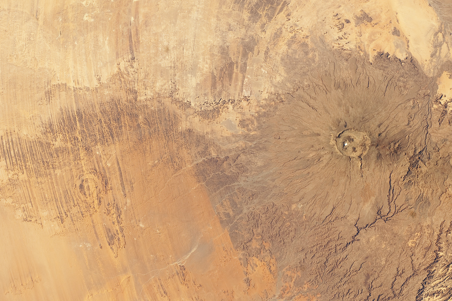
http://www.ouramazingplanet.com/2240-side-side-craters-formation.html
Aorounga Impact Crater
http://en.wikipedia.org/wiki/Aorounga_crater
http://earthobservatory.nasa.gov/IOTD/view.php?id=39727
Emi Koussi Volcano
http://en.wikipedia.org/wiki/Emi_Koussi
http://earthobservatory.nasa.gov/IOTD/view.php?id=3023
Yours,
Paul H.
Moraines Left in Martian Impact Crater by Carbon Dioxide Glaciers
Moraines Left in Martian Impact Crater by Carbon Dioxide Glaciers
Moraines Left by Carbon Dioxide Glaciers on Mars by Dr. Mikhail
Kreslavsky and Prof. James Head, IAG Planetary Geomorphology
Working Group http://www.psi.edu/pgwg/images/Feb12Image.html
The paper is:
Garvin, J. B., J. W. Head, D. R. Marchant, and M. A. Kreslavsky,
2006, High-latitude cold-based glacial deposits on Mars: Multiple
superposed drop moraines in a crater interior at 70°N latitude.
Meteoritics and Planetary Science. vol. 41, pp. 1659-1674.
http://onlinelibrary.wiley.com/doi/10.1111/j.1945-5100.2006.tb00443.x/abstract
PDF files of this paper at:
http://www.planetary.brown.edu/pdfs/3255.pdf
http://www.planetary.brown.edu/html_pages/publications.htm
PDF file of illustrated conference abstract at:
http://www.planetary.brown.edu/m42/m42_19.pdf
A related paper is:
Kreslavsky, M. A. and J. W. Head, 2011, Carbon dioxide glaciers
on Mars: Products of recent low obliquity epochs (?), Icarus.
vol. 216, pp. 111-115.
http://www.sciencedirect.com/science/article/pii/S001910351100337X
PDF file of this paper is at:
http://www.planetary.brown.edu/pdfs/3803.pdf
http://www.planetary.brown.edu/html_pages/publications.htm
There are links to PDF files of lots of papers, including papers
about meteorites at:
http://www.planetary.brown.edu/html_pages/publications.htm
To download the paper just click on the author names, which
are highlighted in red.
Happy Mardi Gras,
Paul H.
Moraines Left by Carbon Dioxide Glaciers on Mars by Dr. Mikhail
Kreslavsky and Prof. James Head, IAG Planetary Geomorphology
Working Group http://www.psi.edu/pgwg/images/Feb12Image.html
The paper is:
Garvin, J. B., J. W. Head, D. R. Marchant, and M. A. Kreslavsky,
2006, High-latitude cold-based glacial deposits on Mars: Multiple
superposed drop moraines in a crater interior at 70°N latitude.
Meteoritics and Planetary Science. vol. 41, pp. 1659-1674.
http://onlinelibrary.wiley.com/doi/10.1111/j.1945-5100.2006.tb00443.x/abstract
PDF files of this paper at:
http://www.planetary.brown.edu/pdfs/3255.pdf
http://www.planetary.brown.edu/html_pages/publications.htm
PDF file of illustrated conference abstract at:
http://www.planetary.brown.edu/m42/m42_19.pdf
A related paper is:
Kreslavsky, M. A. and J. W. Head, 2011, Carbon dioxide glaciers
on Mars: Products of recent low obliquity epochs (?), Icarus.
vol. 216, pp. 111-115.
http://www.sciencedirect.com/science/article/pii/S001910351100337X
PDF file of this paper is at:
http://www.planetary.brown.edu/pdfs/3803.pdf
http://www.planetary.brown.edu/html_pages/publications.htm
There are links to PDF files of lots of papers, including papers
about meteorites at:
http://www.planetary.brown.edu/html_pages/publications.htm
To download the paper just click on the author names, which
are highlighted in red.
Happy Mardi Gras,
Paul H.
Sunday, 22 January 2012
Studying the science of space junk
Studying the science of space junk
Studying the science of space junk by Eryn Brown
Los Angeles Times, January 22, 2012,
http://www.latimes.com/news/local/la-me-space-junk-20120122,0,5399306,full.story
http://www.latimes.com/news/local/la-me-space-junk-20120122,0,819657.story
Space debris cluttering up orbit by Penelope Debelle
Adelaide Now, January 22, 2012
http://www.adelaidenow.com.au/ipad/space-debris-cluttering-up-orbit/story-fn6bqpju-1226249814821
Best wishes,
Paul H.
Studying the science of space junk by Eryn Brown
Los Angeles Times, January 22, 2012,
http://www.latimes.com/news/local/la-me-space-junk-20120122,0,5399306,full.story
http://www.latimes.com/news/local/la-me-space-junk-20120122,0,819657.story
Space debris cluttering up orbit by Penelope Debelle
Adelaide Now, January 22, 2012
http://www.adelaidenow.com.au/ipad/space-debris-cluttering-up-orbit/story-fn6bqpju-1226249814821
Best wishes,
Paul H.
Sunday, 8 January 2012
"The Wave, " A Sight To see in Arizona
"The Wave, " A Sight To see in Arizona
For rock hounds and meteorite collectors going to Tucson, Arizona, a very
popular and beautiful rock formation to visit in northeast
Arizona is the "The Wave" (rock formation). This rock
formation consists of an outcrop of deeply eroded,
large-scale, eolian cross-beds in the Navajo Sandstone
in the Paria Canyon- Vermillion Cliffs Wilderness, in
Coconino County, Arizona. It is so popular that there is
a daily online and onsite lottery that held to determine,
who can visit it on any specific day. A popular article
about it is:
Arizona's Wave rock formation a stone-cold stunner
by Hugo Martín, Times, November 20, 2007,
http://www.venturacountytrails.org/News/0182-TheWaveVermilionCliffs/NewsPage.htm
1. More Photographs of "The Wave" ... and 3.
http://www.zionnational-park.com/images/album2/index4.htm
2. Seiler, W. M., 2008, Jurassic Navajo sandstone of Coyote
Buttes, Utah/Arizona : coloration and diagenetic history,
preservation of a dinosaur trample surface, and terrestrial
analogs to Mars. Unpublished M.S. thesis, Dept. of
Geology and Geophysics, University of Utah, Salt Lake
City, Utah.
The 11.5 MB PDF file is available from
http://content.lib.utah.edu/cgi-bin/showfile.exe?CISOROOT=/us-etd2&CISOPTR=109657&CISOMODE=print
http://content.lib.utah.edu/cdm4/document.php?CISOROOT=/us-etd2&CISOPTR=109657
and 3. Loope, D. B., W. M. Seiler, J. A. Mason, and M. A.
Chan, 2008, Wind scour of Navajo Sandstone at the Wave
(central Colorado Plateau, U.S.A.) Journal of Geology.
vol. 116, pp. 173-183.
Link to PDF file at;
http://digitalcommons.unl.edu/geosciencefacpub/215/
The 1.4 MB PDF file is available from;
http://digitalcommons.unl.edu/cgi/viewcontent.cgi?article=1216&context=geosciencefacpub
By the way, it's a long hike to this rock formation. In addition
a person should bring a GPS too since the trail is very poorly
marked.
Best wishes,
Paul H.
For rock hounds and meteorite collectors going to Tucson, Arizona, a very
popular and beautiful rock formation to visit in northeast
Arizona is the "The Wave" (rock formation). This rock
formation consists of an outcrop of deeply eroded,
large-scale, eolian cross-beds in the Navajo Sandstone
in the Paria Canyon- Vermillion Cliffs Wilderness, in
Coconino County, Arizona. It is so popular that there is
a daily online and onsite lottery that held to determine,
who can visit it on any specific day. A popular article
about it is:
Arizona's Wave rock formation a stone-cold stunner
by Hugo Martín, Times, November 20, 2007,
http://www.venturacountytrails.org/News/0182-TheWaveVermilionCliffs/NewsPage.htm
1. More Photographs of "The Wave" ... and 3.
http://www.zionnational-park.com/images/album2/index4.htm
2. Seiler, W. M., 2008, Jurassic Navajo sandstone of Coyote
Buttes, Utah/Arizona : coloration and diagenetic history,
preservation of a dinosaur trample surface, and terrestrial
analogs to Mars. Unpublished M.S. thesis, Dept. of
Geology and Geophysics, University of Utah, Salt Lake
City, Utah.
The 11.5 MB PDF file is available from
http://content.lib.utah.edu/cgi-bin/showfile.exe?CISOROOT=/us-etd2&CISOPTR=109657&CISOMODE=print
http://content.lib.utah.edu/cdm4/document.php?CISOROOT=/us-etd2&CISOPTR=109657
and 3. Loope, D. B., W. M. Seiler, J. A. Mason, and M. A.
Chan, 2008, Wind scour of Navajo Sandstone at the Wave
(central Colorado Plateau, U.S.A.) Journal of Geology.
vol. 116, pp. 173-183.
Link to PDF file at;
http://digitalcommons.unl.edu/geosciencefacpub/215/
The 1.4 MB PDF file is available from;
http://digitalcommons.unl.edu/cgi/viewcontent.cgi?article=1216&context=geosciencefacpub
By the way, it's a long hike to this rock formation. In addition
a person should bring a GPS too since the trail is very poorly
marked.
Best wishes,
Paul H.
Tuesday, 3 January 2012
Weathering profiles on Earth and Mars
Weathering profiles on Earth and Mars
The web page below is an interesting site of images
and text explanation.
Weathering profiles on Earth and Mars by Anne Gaudin,
University Nantes, CNRS, Laboratoire LPGN, France
Featured images for January 2012, IAG Planetary
Geomorphology Working Group
http://www.psi.edu/pgwg/images/Jan12Image.html
The paper is:
Gaudin, A., E. Dehouck, N. Mangold, 2011, Evidence for
weathering on early Mars from a comparison with terrestrial
weathering profiles. Icarus. vol. 216, no. 1, pp. 257-268.
http://www.sciencedirect.com/science/article/pii/S0019103511003496
Best wishes,
Paul H.
and text explanation.
Weathering profiles on Earth and Mars by Anne Gaudin,
University Nantes, CNRS, Laboratoire LPGN, France
Featured images for January 2012, IAG Planetary
Geomorphology Working Group
http://www.psi.edu/pgwg/images/Jan12Image.html
The paper is:
Gaudin, A., E. Dehouck, N. Mangold, 2011, Evidence for
weathering on early Mars from a comparison with terrestrial
weathering profiles. Icarus. vol. 216, no. 1, pp. 257-268.
http://www.sciencedirect.com/science/article/pii/S0019103511003496
Best wishes,
Paul H.
Sunday, 1 January 2012
A Meteorite Did Not Start Fire in San Francisco
A Meteorite Did Not Start Fire in San Francisco
A Meteorite Didn’t Start Today’s Six Alarm
Fire in San Francisco by Roberto Baldwin
Gizmodo, Science, December 31, 2011
http://gizmodo.com/5870615/a-meteorite-didnt-start-todays-six-alarm-fire-in-san-francisco
http://www.gizmodo.com.au/2011/12/a-meteorite-didnt-start-todays-six-alarm-fire-in-san-francisco/
Twitter Urban Legend: A Meteorite Didn’t
Start Today’s Six Alarm Fire in San Francisco
by Sharon Hill, December 25, 2011
Happy New Year Everyone
Paul H.
Fire in San Francisco by Roberto Baldwin
Gizmodo, Science, December 31, 2011
http://gizmodo.com/5870615/a-meteorite-didnt-start-todays-six-alarm-fire-in-san-francisco
http://www.gizmodo.com.au/2011/12/a-meteorite-didnt-start-todays-six-alarm-fire-in-san-francisco/
Twitter Urban Legend: A Meteorite Didn’t
Start Today’s Six Alarm Fire in San Francisco
by Sharon Hill, December 25, 2011
Happy New Year Everyone
Paul H.
Subscribe to:
Posts (Atom)